Transcript
Automated transcript · Written by software from the replay's audio. It can mishear names and figures; the replay is the record.
0:07 Hello everyone and thank you for joining this live Capital Light event. We are joined by their CEO and Director, Brian Boss, and their Geoscientist and Fellow Director, Douglas Macquarie. Today we have another exciting event with a similar format as last event if you participated. I'm going to play a 16 minute recording of some on-site footage and following the video Brian and Douglas will be available for questions if you have any. So please feel free to submit your questions at any point during the conversation, it's just that little text box in the bottom right corner of your screen. I also want to remind you that this
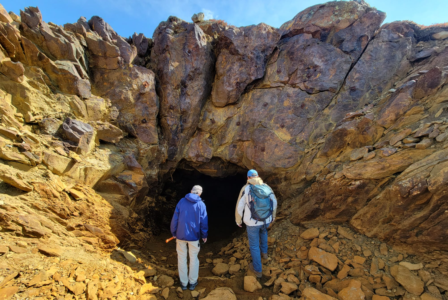
0:39 event is being recorded and the replay will be available a few hours after the event concludes. So with that being said I'm just gonna share my screen here and we can start the video. So here we are again at the mouth of the decline or the mouth of the adit.
1:30 We just want to point out what we're learning here about the rocks. So you can see the rocks are not horizontal, they're dipping. I'll turn the camera to line up with the rocks. And that's maybe a 60% decline. So now the rocks are in a straight line heading down into the earth. I'll bring the camera back here. And so that's telling us, obviously that the rocks were not created at that angle. They were created at flat lying and they've been thrust upwards. We think that's from the action of the Labrador trough when what is now Labrador bumped into the largest piece of North America called the Superior Craton. Bumped is a word that describes a hundred million years of activity.
2:19 And the mouth of the decline here is right where that really soft rock in small pieces meets the larger rock, and then as we get deeper in it's large rock only. Let's see if I can turn on the light. Okay, so we're standing at the mouth of the adit that was driven in the 1980s. And this is partially filled with water but as we understand that it goes for 300 feet and we have hand-drawn maps of the Adit from the era in the 1980s where they have sampled the walls of this and it ranges from, well there's lots of range, but I'd say the mean is 1 and a half percent sometimes it's 3 percent 2 different locations. That's copper only And there's nickel on top of that that they sampled which is running about half the 0.7 And then there's platinum and palladium all came out of this in hand-drawn mappings and we're working on learning more.
4:02 We just landed on Blue Lake and we're looking at some of the rocks that the geoteams have seen in the previous days. So we've got Doug and Thibault the pilot and Thibault's just picked up a shiny rock and Doug's just picked up another rock and we're gonna hear from Doug. Same stuff, but on a fracture surface. As you can see right here at the tip. They can see. They're little cubes of pyrite. So this is iron sulfide and it's the thought is that the sulfur that ended up in the massive sulfides that we're hoping to find like the material in the waste at the adit, the sulfur came from these rocks and where it combined with the ultramafic, the sulfur went into the ultramafic, scavenged the copper, the nickel, the platinum, and the palladium, and then precipitated out into those massive sulfides. So, this is evidence of sulfides in the host rock. It It's intruded by the seals.
5:24 Okay. Okay we're at the attic. Doug's just knocked a corner off. So, tell us about this Doug. Okay, so this is the massive salt mine, which is what we're looking for. This is what our 5 million tons of resources is made of. This particular sample has quite a little bit of copper showing. So that is what we're really looking for. This is the 5-7% copper. The variety in maybe this section is the 1 or 2% copper. So, if some of it is 5 to 7 and some of it is 1 to 2, all of that sounds really good. Because 1 to 2 is more than enough.
6:16 But why is it some is 5 and some is 1? That's a good question. So that's... That'll be... Probably we discovered about 5 years ago. But we drilled the hell out of it and did a lot more work on the rocks. It becomes quite academic. So our job is to find the orbital and the academics. Very nice. Very heavy. Density 4.3. So the gravity meter finds heavy rocks
6:50 so what does 4.3 mean Doug okay so water is 1 2.65. This material, the black shales and stuff, probably 2.7. And a little bit of salt, probably 2.75. And the ultrathick silts, which are on the hills behind us here, those are about 3.2. But this rock is, look, is
7:27 4.3. So the gravity just finds places where there's a concentration of mass. And that's what we're looking for. And we pray that the gravity comes up with some significant high masses that have not been drill tested. We've had an added drill done on them. The property is so big that surely, you know, there's something left to be found here so we're exploring we're on the discovery we're on the discovery trend which is the most exciting phase of any exploration company you go from having something small to finding something big. That's what we're here for.
8:21 Okay, so we're at Ready Lake Camp. We're about to go through the day's rock haul. Doug is coming down the boardwalk here
8:32 and Doug and the Geos will talk about what they've got today. Lots of rocks. So yeah, we followed the sill, kind of a foliated section, all through like the long 600 meters. And throughout was rusted, quite lots of sulfides in it. And we saw like, so this is chunks of calco all around. Some areas were better than the others. Nice, so where were you? Close to the, this Western hinge of the big hole we have like cheering but Not the usual like the salt shear and it's so hard.
9:30 So it's got pure titan here. So it's got pure tight, yeah? Not bad. Very tight. Very tight. Can I pull it this way? Yep. That's what we're looking for. I think she should be good. That's a good one. Super looking. She should be in there somewhere. Yeah, for sure. Baby in. Yeah, quite good count. Was this your rock? No, it was not my unit. Yeah, it's a good count. That's my home.
10:16 It's, yeah, we were following the same rock over about 600 meters so most of them it's mostly all the same unit. So this this is the host rock
10:31 and you know to see that level of chalcopyrite just in the host rock that's that's great. That's really good. That's the whole theory of this. Some places have more proper nickel plant of land than others. So let's find the rich spots and then we can concentrate. So the eastern limb, we didn't see that much. We didn't find the sheared area. We only had the host rock itself. Some areas contained copper minerals, but very little. This is good. And there you are, slightly magnetic.
11:19 So it will be...
11:21 We've flown most of our old planes with airborne magnetics and electromagnetics. And this would show up as a weak magnetic target. So we know we're not looking at the strong, strong magnetic targets. We should be searching those more. Magnestruction throughout. Exactly. Yeah. And look at this. It's hardly magnetic at all. Very low, very low pyrrhotite, but good chalcopyrite in it. So that's the whole point, if we just randomly sample everything, take 2,000 samples and assay them, you know, we're gonna find something.
12:08 And we'll understand what we have. Yep, and we'll know where to come back and look for closer. Nicole is not done. These are the 2 best samples I had. Did you get like 10,000 BPM on one of your samples? I'm not sure. Maybe both. Nice. Very tight width.
12:37 Not quite strong enough to hold it, but yeah, almost. It's strong. Great.
12:48 Mixing up all your rocks. No, I think we're doing good right now. Yeah, nice. The blades of chalcopyrite all through it. Very nice. So Doug, is this from an area we already had inside the 5 million ton camp? I'm not sure, we're going to have to look at that. It's the highland.
13:23 Well, anything up there is not in the count. The count is Pogo Center and Blue Lake 1 to 5. That's the highland. The reserve. Yeah, so this is outside of that. Reserves, I should say. Let's make something crazy. So this one which is about the least mineralized of those pulled out 1900 copper and 1400 nickel. 0.2 and 0.14. 0.34, 0.4, 0.5 copper.
14:02 So here we have 4600 nickel and 3400 copper but that's the nodule
14:33 fantastic that's what we're looking for yeah This is the low grade we're looking for. Yeah, exactly. Yeah. This is So we're closing in on the second hinge, so the anticline. Hey, come and show me the other way. We just passed the syncline, and then we're going to the anticline. Where's the supermassive? So you've got visible copper here?
15:04 Visible copper pyrite. Copper minerals, yeah. That's a big chunk. Right there you mean? Yep. Quite strong. And finer grained. It doesn't seem as dense. It seems. It doesn't? It should be, but... To me it seems pretty dense. To me too. But I didn't carry it all day. Yeah, no, carefully enough.
15:44 That's good. There's a bigger one. It's not as boring a rock as we thought Another great video. Thank you guys for sharing that. Douglas, it was nice seeing you interact with everyone on camp there.
16:56 For this Q&A, we have it switched. Now Douglas is actually at the Blue Lake Camp. So for anyone that came in a little late, just a reminder, we are taking questions. Please feel free to submit them in the bottom right corner of your screen. There was a couple that came in via email, so I'll get started with those. I'm gonna direct this one toward you, Douglas. How do gravity and LiDAR technologies complement each other in identifying ore bodies at Blue Lake? And what advantages do they offer over traditional exploration methods? Okay, so LiDAR is basically a system of measuring the elevations quite accurately over a fairly large area. So in order to get the best gravity data you need very good elevation control and you need to know elevation data beyond say 500 meters to to do corrections to the data.
17:56 So the gravity targets we're looking for obviously we're looking for an elephant. You know if there's an elephant there that's nice, They show up quite easily. But a 4 or 515, 10 million ton target, which is very nice to find, they're going to be smaller responses. And so you have to get your noise levels down. And so you do the LIDAR to get the best gravity data possible. They're independent surveys. Great, thank you for that. And you mentioned elephants. This is a vast area you're looking at, if I'm not mistaken, 500 square kilometers. So what are the main challenges of systematically covering such a large site and how are you prioritizing different zones?
18:45 Okay, it turns out, it turns out it is a very large area, but 1 always starts with a bigger clean group than necessary. One doesn't want to find an ore body on somebody else's land. So we acquired the extra property just to make sure we had elbow room. It turns out the copper, nickel, platinum, palladium, the source rock is the ultramafic. And the biggest hunk of ultramafic will be the biggest source of potential mineralization. So we're concentrating right now on prospecting with 4 two-man, two-person crews, sampling everything that's on a known conductor, a known mag zone, or is rusty and is outcropping.
19:37 So basically we're going to collect somewhere between 1400 and 2000 samples, somewhat weather dependent,
19:48 and basically analyze them. You can't see platinum palladium in the rocks, you must assay. Likewise, rocks that are heavily, heavily oxidized, it's hard to even get a good sample of them. But the assays will say, hey, there's lots of copper and nickel in this, so you can go back again. So we're going to concentrate in the thickest parts of the sill with conductors and with magnetic anomalies and from there move out to the other parts as time allows, yeah. Thank you, and in the video, there was quite a bit of time spent at those adit piles. What's the significance in that and the exploration process, if it changes it at all? And does it relate to potential of deeper pods?
20:37 Yeah, for sure. If you look at a bit of the history on some of these large ultramethic hosted deposits, the massive sulfites can have significant links to them, 1 kilometer, 2 kilometers. And obviously that was when they were originally laid down, perhaps they were horizontal. Now they've been folded, they've been metamorphosed, and they could be at different orientations. So sure, why not? Raglan, I believe is down almost at a kilometer in depth. And some of the Australian deposits have been mined out to that kind of depth. We know that the mineralized sill here is 60 kilometers long.
21:29 Does that mean the massive sulfides that we hope to make an ore body out are 60 kilometers long? Of course not, but that's the size target. So if you think something had the energy to flow 60 kilometers, why can't it now be going down 2 kilometers? It's obviously harder to find, et cetera, more costly to mine, all of those factors come in. But that is an economic consideration depending on the value of the mineral you find. And until we find it, we're just going to have to wait to put those other parameters on. So let's say you confirm that it is that deep, like 2 kilometers, like you say is very deep. If you do find that there's the presence there, 2 kilometers deep, what would the next steps be for capital light in terms of further exploration?
22:19 Okay, so you know as as things get deeper the signals get weaker. So a 10 million ton ore body at surface the gravity will find it, the EM will find it, the magnetometer will find it. As you go down to 500 meters, the signals all get weaker. But there are downhole techniques. So if you know, you say have a plunging chute, you know, say it outcrops here and the chute plunges. Well, you can put a drill hole here and do downhole techniques, downhole EM that says, hey, there's a conductor over here, which will target your drilling. So you can refine your drilling quite a bit once you're onto a known oriferous structure.
23:10 Maybe I'll get Brian in the conversation here with this question. How does Blue Lake compare to other projects in northern Quebec in terms of geological potential and resource estimates? What sets it apart in terms of exploration opportunity? Actually, while we were waiting for me to have a chance to say anything, I was remarking to myself that we have an excellent team. I mean, you've just heard 16 minutes of Doug talking. Doug was talking about rocking the video and then he spent another 8 minutes so far explaining what we're doing. And I'm super excited that we have him, that he's interested in this, and that he's been funding it, to be honest, for exploration. So I just wanted to put that across. And I think as long as Doug's excited, everyone else should be super ecstatic. And that's where we're at right now.
24:02 But having said that, Kyle, give me the question again. Yeah, no problem. Sorry, I didn't give you any time to relate this to the rest of them. Come on, Doug, give me the answers here. All right. So here, I'll relay the message here just as a reminder for everyone. How does the Blue Lake project compare to other projects in northern Quebec in terms of geological potential and resource estimates and what sets it apart? Okay, so there's a lot of conversation going on in the company right now about, you know, what are we learning in the camp and what is the camp knowledge teaching us about what the right mental model is to inform what we're going to do next. So there's 2 obvious things. One is Raglan, which is an existing mine already in operations, found in the
24:49 1990s, I think, by Falkenbridge, is now owned by Glencore. It's in the same geologic event zone called the Labrador Trough. It also is collections of pods, some of which are high up at the surface, some of which are down, lower down. It's also copper, nickel, platinum, palladium in roughly the same ratios between the metals.
25:16 And that's actually one of the first things that made us get serious about gravity, which is that you're not expecting to see an ore body at surface and then continually go all the way down. There might be a break or a movement, you know, the ore body might have started like this and then be over here in a crumpled pile and then be over there. So gravity is what's going to help us look down, that's the first thing. Second is the idea of how Mother Nature laid this deposit down, again, should be very similar to Raglan, but it's early days, but we think both Raglan and this are similar to Western Australia, where there's nickel deposits that seem to have come from the same type of system.
26:04 So
26:05 we're not reinventing the wheel. We're just, we're in a place where no one's really looked with the tools they should have been looking with. And with the tools that were outdated, they've already found 5 million tons. So with all of these great tools and with Doug, we expect we're gonna find something fantastic and to aid our search, we're keeping in mind that there are already deposits that should be a guidepost for us and how to look. Douglas, do you have any further commentary on what sets Blue Lake apart? Okay, so it's just a really, really big system. And if you have a little bit of metal dispersed through this massive amount of ultramafic material,
27:02 Well, that adds up to, well, an awful lot of metal. And I think we talked about it previously, the Lake Sediment Survey says that our entire claim group, the lake sediments have 200 parts per million copper. I think the average in the world is maybe 30 or 40 ppm copper. So where'd all that copper come from?
27:33 It all has to lead back to a source. And we know that mineralization can concentrate to levels of 1, 2% and more nickel, 1%, I'm sorry, 1 to 2% copper, 1% nickel, 1234 grams, platinum, we know the geology, the chemistry works. And we know that because we have the blue lake added and the material. That's a tiny little piece of this concession. So the odds of there being more of those, it's quite typical, I believe, at the project in Australia. There's like 10 different mines
28:14 around this. We've got mineralization that Fred, the geologist, was talking about up in the fold zone. It looks like really good copper in the ultramafic. That's 15 kilometers from the Blue Lake massive sulfides. You go 15 kilometers in the other direction to the south, similar material. So there's potentially very good grade mineralization occurring over large areas. Is there going to be a concentration sufficient to make a mine in any of those? Well, time will tell. I bet there will be. I'll pass it back to you, Brian. What timelines can investors expect for updates regarding exploration results?
29:01 Okay, so camp opened on August 21st for the Geos. We're gonna run the camp until either Mother Nature shuts us down with a big snowfall or September 30th, probably, whichever comes first. But yeah, we think we'll be there all month. Doug is, Doug's gonna leave the camp and I will go back to camp and then I'll be there throughout the camp. We're having a small debate about also doing a winterization for at least one of the cabins so that we can come back in the winter. So you've heard 1400 to 2000 rock samples. Those assays will be shipped out to the lab when the camp ends, so they'll arrive to the lab probably the first or second week of October.
29:50 We expect to get results back late November as a guesstimate.
29:56 So that's on samples like you saw in the videos. Then We didn't show any videos of how gravity measures are taken. We might get that in the third installment of these videos. But it's very much a data process. So the data gets taken every day, And then at the end of the campaign, all the data gets consolidated into one giant database, and then the math and the computation start. Whereas you heard on the video, Doug talks about how different weights have different, sorry, different rocks have different densities.
30:28 So now you're essentially solving a math equation where you have a total density at a particular depth, and you ask yourself what type of rocks would have equaled the density I observed, and that takes time, so maybe again
30:42 late November, December, maybe we'll see those initial results, And then as Doug said earlier on, you need to improve all that math by having the LiDAR data, which tells you, oh, there's a hill over there on the surface. And so that changes the math a little bit of how much you measure down in the ground, because although we don't think about it on this planet, all things attract all other things. That's why we do the LiDAR survey. So yeah, it could be into this late November before we get to see 3D guesstimates or 3D first images of what's underground. And there's going to be a long period of study, I mean, desktop study, figuring out what there is showing, what does that tell us to do next? And rather than hog the microphone, I'll hand that back to Doug.
31:34 Yeah, Brian, I think you've hit the nail on the head. So it's a huge area, we're building up our database. There will be copper, nickel, platinum, palladium concentrations that come out of our sampling. Areas that we don't know about. Areas that have not been previously sampled. So we got to put our thinking caps on and say, okay, we got 3 areas, 5 areas, 2 areas, 10 areas.
32:00 What's the program for next year? And then come and hit it hard. I don't know if we'll have a drill target for the freeze up. Perhaps we will if the gravity comes up with something quite significant, that would be drivable. Other than that, we're probably gonna have to do more sampling and more ground geophysics and then aim for a summer drill program next year. Yeah, but still a lot to look forward to for the last quarter of 2024.
32:32 I have one final. Before you move on, actually, a few more things just came into my head about the last quarter of 2024, and before I get to those, I'm just going to reiterate something that Doug's always said to me, and I don't think he said it loudly on this call yet, The time to drill is, it's almost like a lawyer never asks a question he doesn't already know the answer to. The time to drill is when you already know what you think you're going to find. So we want to, we want to study, study, study, and then drill once instead of drilling 5 times and discover we've missed it 4 times. That's the approach we're taking. And we're doing that because A, it's been very successful for Douglas in the past and B, Between us, we own half the company, so we're not interested in throwing a bunch of drill holes down and putting out press releases that aren't really constructive about getting towards an economic discovery.
33:28 We need to think, study, think, study, then drill. And then what are we gonna do? We have, as shareholders know, we normally have our AGM in June. We were talking about an AGM for late November, early December for this year, meaning in this calendar year, to refer to the 2023 fiscal year that's over. And the reason why we're thinking about that timing is because there's lots of special items we need to deal with at an AGM, but of course, everyone's gonna have a lot of questions about what the results are for what we found. So that's probably the perfect time. Once we get a handle on when all these results are going to come in, that would be a great time to do an AGM because then you can have 3, 4 hours of deep conversation with the shareholders in person, go through everything and explain it in a way that you just can't do on video.
34:24 Exactly. Exactly. That's a great way to sum this up. I'm going to pass it to Douglas for the final word. But before that, I just want to remind people this event is being recorded, so if you came in late, the replay will be available in a couple of hours on YouTube. Just go to our sixth channel on YouTube. But this last question, I think, adds it up nicely. So I let Douglas wrap this up with this final question. What specific factors make you confident that Blue Lake has the potential to reveal large scale commercially viable ore deposits? I think, thanks Kyle. I think that the simple answer is where there is smoke, there is fire. And there's little brushy, smoky things all over this property. And I just learned recently that some Quebec assessment report data, there's some actually significant gold showings on our current claims.
35:23 And there are significant amounts of gold in the grams over meters in very rusty gossam rock that's being sampled. All of the samples that we've taken will also run for gold. There might be a surprise here yet. Excellent. Gentlemen, thank you so much for your time and the format. I love the format, how we're doing this, and I'm excited there's going to be a third part. So looking forward to that. But thank you. Thank you