

HIGHLIGHTS
Recent exploration by Novo at the Clone prospect included detailed structural, lithological and regolith mapping, pXRF and < 80# mesh soil sampling, and rock chip sampling.
Novo rock chip sampling returned peak results of 89.6 g/t Au and 41.9 g/t Au from mullock dump samples associated with historical workings, and 31.4 g/t Au and 10.4 g/t Au from quartz vein outcrop over 700 m of strike, supporting previous high grade drill results.
Soil sampling defined a ~ 600 m long and up to 250 m wide coherent anomaly > 30 ppb Au, with peak results of 1,585 ppb Au and 1,440 ppb Au.
Mapping defined a west dipping thrust (Clone Thrust) associated with high grade gold mineralisation and significant sericite-carbonate alteration.
A ~2,000 m targeted RC drill program is planned to commence in April 2025 to test this high-grade gold mineralised trend.
RC drilling at Clone completed by Manhattan Corporation Limited (ASX: MHC) in 2023, highlighted potential for shallow dipping high-grade gold mineralisation, with excellent drill results returned from 11 holes including1:
7 m at 7.23 g/t Au from 81 m, including 3 m at 16.1 g/t Au (CL0007)
9 m at 6.03 g/t Au from 16 m (CL0010)
6 m at 4.22 g/t Au from 66 m, including 2 m at 11.65 g/t Au (CL0004)
31 m at 1.29 g/t Au from 60 m, including 3 m at 6.52 g/t Au (CL0002)
The Manhattan RC program tested some 250 m strike of an interpreted trend > 700 m to a maximum depth below surface of 75 m.
The Clone prospect is underexplored with mineralisation open in all directions and trending under cover to the south.
The southern cover sediments extend for up to 15 km over the prospective target basement corridor and provide opportunities to explore for potential ‘blind discoveries’.
Mike Spreadborough, Executive Co-Chairman and Acting Chief Executive Officer, said: “We look forward to commencing our RC drill program at the Clone prospect, which forms part of our Tibooburra Gold Project, located in northwestern NSW.
“Tibooburra is a standout exploration opportunity due to previous high-grade drilling results and compelling exploration upside. We aim to start drilling this month and the program we have developed will test several priority gold targets which were identified through our recently completed three-week reconnaissance program. The remainder of 2025 is set to be a busy year exploration-wise for Novo and we are focused on executing on our strategy and delivering significant value to our shareholders.”
PERTH, Australia, April 01, 2025 (GLOBE NEWSWIRE) -- Novo Resources Corp. (Novo or the Company) (ASX: NVO) (TSX: NVO) (OTCQB: NSRPF) is pleased to announce that an RC program at the Tibooburra Gold Project (Tibooburra) (Figure 1), located in northwestern NSW is planned to commence in April 2025. The drill program will focus on the Clone prospect (Figures 2 and 3) over a strike of several hundred metres and is designed to test high-grade gold targets recently confirmed during a successful three-week field campaign of mapping and surface sampling.
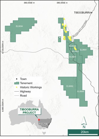
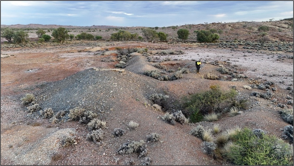
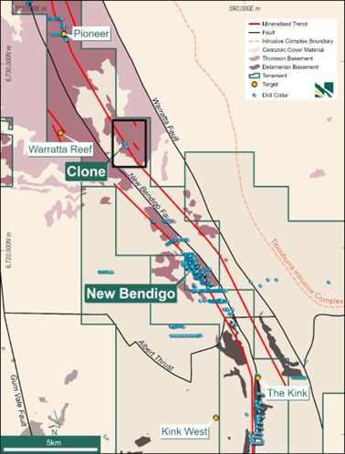
Figure 3: Tibooburra project tenure, with regional geology, drill collars, main prospects, highlighting multiple parallel mineralised trends.
Tibooburra is an advanced exploration opportunity which covers much of the historic Albert Goldfield (Figure 1). Tenure includes six granted exploration licences over 630 sq km.
The agreement with Manhattan Corporation Limited (ASX: MHC) (Manhattan)2 grants Novo an option to acquire a 70% interest in the tenements comprising this tenure, subject to (among other things) Novo meeting two minimum expenditure requirements over two 12 month periods. Refer to Novo’s 13 December 2024 news release titled “Novo strengthens portfolio with two High-Grade gold projects in NSW, Australia” for the detailed terms of the agreement with Manhattan.
Geological mapping and surface sampling of the Clone trend defined several targets that warrant drill testing or further surface geochemical sampling and review. Results from minus 80# mesh soil sampling confirmed Au anomalism associated with the Clone Thrust and splay structures, with rock chip sampling confirming high-grade gold mineralisation within the main zone of workings.
An initial Novo RC drill program of ~ 2,000 m is planned to commence in April 2025 and will target the main zone of historical workings at Clone over ~700 m of strike.
Overview
The Albert Goldfields lies on a unique district-scale bend at the boundary of the Thomson and Delamarian orogens, with stratigraphy wrapping around the Tibooburra granite intrusive complex to the northeast.
Over 200 historic workings on multiple lines, delineating over 34 km of interpreted mineralised trends have been identified at Tibooburra. Several targets were highlighted by Manhattan including New Bendigo, Clone, Pioneer, Elizabeth Reef and Good Friday (Figure 3). However, outside of the New Bendigo prospect, little systematic modern exploration has been conducted. The area is significantly under-explored, and satellite imagery and interpretation show untested cover sequences, particularly in the south. At Clone, extensive historical workings manifest over ~450 m strike and 20 m to 40 m in depth.
RC drilling by Manhattan in 2023 highlighted potential for shallow dipping high-grade gold mineralisation. Excellent drill results were returned in fresh rock from an initial 11-hole RC drill program testing 250 m strike to a maximum depth below surface of 75 m, including2:
7 m at 7.23 g/t Au from 81 m, including 3 m at 16.1 g/t Au (CL0007)
9 m at 6.03 g/t Au from 16 m (CL0010)
6 m at 4.22 g/t Au from 66 m, including 2 m at 11.65 g/t Au (CL0004)
31 m at 1.29 g/t Au from 60 m, including 3 m at 6.52 g/t Au (CL0002)
This mineralisation remains open in all directions, with targeted mineralised basement trending under cover sediments to the south. The cover sediments extend for some 15 km providing opportunities for exploration targeting potential ‘blind discoveries’.
Novo has not conducted data verification (as that term is defined in National Instrument 43-101 Standards of Disclosure for Mineral Projects and JORC 2012) in respect of the above data from New Bendigo and Clone and therefore is not to be regarded as reporting, adopting or endorsing those results/figures. No assurance can be given that Novo will achieve similar results.
Recent Soil and Rock Chip Sample Results
A three-week field campaign comprising geochemical surface sampling and detailed mapping of the main ~ 3 km strike at the Clone prospect was completed in February 2025, with all assay results returned. The field programs were devised to investigate controls on gold mineralisation and allowed Novo to design a follow up RC drilling program to validate previous drill results. Novo is anticipating that this program may significantly extend known mineralisation along strike, down dip and down-plunge.
Results from all aspects of the exploration work proved extremely promising, supporting the decision to commit to ~2,000 m of RC drilling at Clone in April 2025.
Mapping identified a package of folded and sheared deep marine meta-sediments ranging from siltstone (shale and slate) to phyllite with limited variation in grain size. Metamorphism of the host rocks is greenschist facies. Structure in the mapping area is dominated by complex folding (possibly multi-phase) including interpreted isoclinal folding in the immediate Clone area, overprinted by a strong NW trending regional foliation.
Mineralised late-stage NNW to NW trending moderately southwest dipping shears (interpreted as reverse faults) have been the focus for much of the historical workings. Generally, the best mineralisation occurs where these structures bend in a more northerly direction (Figure 4), producing 1 m to 10 m wide shear zones. The main shear, the Clone Thrust, is traceable over 3 km strike and trends under cover to the NW and SE. Several splay structures are also present and are potentially part of the fertile architecture of the belt (Figure 4 and Figure 5). NNE trending cross-cutting faults are common, with interpreted sinistral movement on the main shear zones. Mineralised veining includes west dipping late-stage quartz veins which vary between laminated, massive, brecciated and sheared, and contain rare sulphide and green sericite.
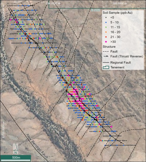
Figure 4: Structural mapping and thematically mapped minus 80# mesh soil samples over the ~ 3 km Clone Trend
Alteration, especially in these mineralised shears, is dominated by intense sericite and minor sulphides (pyrite and arsenopyrite). Green sericite is present on quartz vein selvedges in almost all historic workings. A broad strong zone of alteration is present between the Clone Thrust and the Western Splay adjacent to the main Clone target.
Conventional minus 80# mesh soil sampling on a nominal grid of 20 m x 40 m over areas of historical workings, extending to 20 m x 80 m to the north and south, has defined a 600 m long coherent > 30 ppb Au anomaly with peak results of 1,585 ppb Au and 1,440 ppb Au over the main target area. See Appendix 1 for significant soil sample results.
Rock chip sampling (Figure 5 and Figure 6) yielded peak results of 89.6 g/t Au and 41.9 g/t Au from mullock dump samples at the northern end of the main Clone workings. The samples comprised sheared phyllite with multiple centimetre scale quartz veinlets and minor boxwork after sulphides. In the southern part of the main workings, peak results include 31.4 g/t Au and 10.4 g/t Au from within the west dipping Clone Thrust (Figure 7). Several samples collected in the main area graded > 3 g/t Au. See Appendix 2 for all rock sample results.
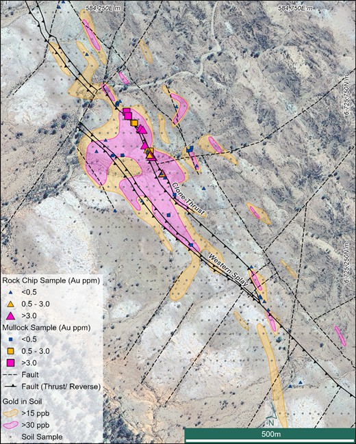
Figure 5: Soil sampling anomaly and rock chip sampling across the main Clone Prospect
High-grade gold assay results may highlight the potential for a coarse component of gold in the mineralised system at Clone, leading to difficulties in obtaining accurate rock chip results. A program of 20-30 samples grading > 0.1 g/t Au will be re-assayed via screen-fire assay to assess the coarse gold deportment and better inform assays of drill samples.
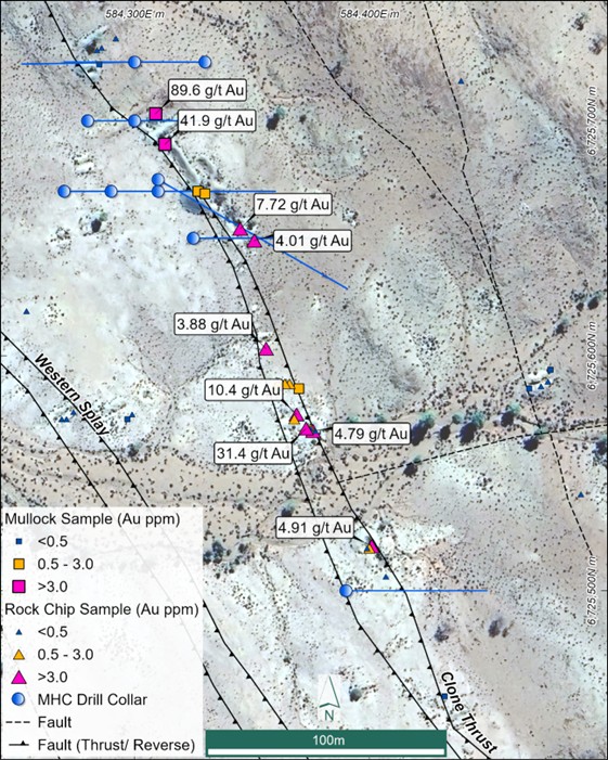
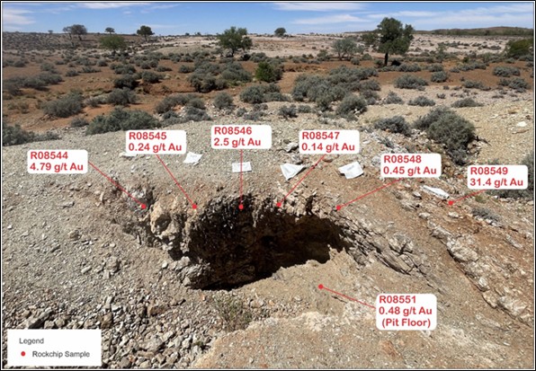
Figure 7: Rock chip sample results from an exposure of the west dipping Clone Thrust, highlighting a significant high-grade zone of mineralisation over approx. 8 m width with a peak result of 31.4 g/t Au from the western-most quartz vein; results may not be indicative of mineralisation in the district
Planned RC Drill Program
Geological mapping and surface sampling of the Clone trend defined several targets that warrant drill testing or further surface geochemical sampling and review.
Results from minus 80# mesh soil sampling confirmed Au anomalism associated with the Clone Thrust and splay structures, with rock chip sampling confirming high-grade gold mineralisation within the main zone of workings.
The initial RC drill program of ~ 2,000 m is planned to commence in April 2025 and will target the main zone of historical workings at Clone over ~700 m of strike.
A heritage survey has been completed by the Tibooburra Local Aboriginal Land Council (TLALC), with no heritage sites located on the drill pads or the field track required to access the northern drill holes. An APO for all proposed drillholes and the northern access track was successfully returned in March.
Authorised for release by the Board of Directors.
CONTACT
Investors: | North American Queries: | Media: |
QP STATEMENT
Mrs. Karen (Kas) De Luca (MAIG), is the qualified person, as defined under National Instrument 43-101 Standards of Disclosure for Mineral Projects, responsible for, and having reviewed and approved, the technical information contained in this news release. Mrs De Luca is Novo’s General Manager Exploration.
JORC COMPLIANCE STATEMENT
The information in this news release that relates to previously reported Exploration Results from Novo’s NSW Gold Portfolio is extracted from Novo's ASX announcement entitled Novo Strengthens Portfolio with Two High-Grade Gold Projects in NSW, Australia released to ASX on 13 December 2024 which is available to view at www.asx.com.au. The Company confirms that it is not aware of any new information or data that materially affects the information included in the original market announcement and that all material assumptions and technical parameters underpinning the estimates in the relevant market announcement continue to apply and have not materially changed. The Company confirms that the form and context in which the competent persons findings are presented have not been materially modified from the original market announcement.
The information in this news release that relates to the previously reported exploration target at Belltopper is extracted from Novo’s ASX announcement entitled Belltopper Mineralisation Modelling Defines Prospectivity released to ASX on 25 September 2024 which is available to view at www.asx.com.au. The Company confirms that it is not aware of any new information or data that materially affects the information in the original market announcement and that the form and context in which the Competent Person’s findings are presented has not been materially modified from the original market announcement.
FORWARD-LOOKING STATEMENTS
Some statements in this news release may contain “forward-looking statements” within the meaning of Canadian and Australian securities law and regulations. In this news release, such statements include but are not limited to planned exploration activities and the timing of such. These statements address future events and conditions and, as such, involve known and unknown risks, uncertainties and other factors which may cause the actual results, performance or achievements to be materially different from any future results, performance or achievements expressed or implied by the statements. Such factors include, without limitation, customary risks of the resource industry and the risk factors identified in Novo’s annual information form for the year ended December 31, 2024 (which is available under Novo’s profile on SEDAR+ at www.sedarplus.ca and at www.asx.com.au) and in the Company’s prospectus dated 2 August 2023 which is available at www.asx.com.au. Forward-looking statements speak only as of the date those statements are made. Except as required by applicable law, Novo assumes no obligation to update or to publicly announce the results of any change to any forward-looking statement contained or incorporated by reference herein to reflect actual results, future events or developments, changes in assumptions or changes in other factors affecting the forward-looking statements. If Novo updates any forward-looking statement(s), no inference should be drawn that the Company will make additional updates with respect to those or other forward-looking statements.
__________________
1 Refer to ASX news release by Manhattan Corp dated 10/07/2023 – New High-Grade Gold Discovery
2 Refer to ASX news release by Novo Resources dated 13/12/2024 – Novo Strengthens Portfolio with Two High-Grade Gold Projects in NSW, Australia.
ABOUT NOVO
Novo is an Australian based gold explorer listed on the ASX and the TSX focussed on discovering standalone gold projects with > 1 Moz development potential. Novo is an innovative gold explorer with a significant land package covering approximately 5,500 square kilometres in the Pilbara region of Western Australia, along with the 22 square kilometre Belltopper project in the Bendigo Tectonic Zone of Victoria, Australia.
Novo’s key project area in the Pilbara is the Egina Gold Camp, where De Grey Mining is farming-in to form a JV at the Becher Project and surrounding tenements through exploration expenditure of A$25 million within 4 years for a 50% interest. The Becher Project has similar geological characteristics as De Grey’s 12.7 Moz Hemi Project#. Novo is also advancing gold exploration south of Becher in the Egina Gold Camp, part of the Croydon JV (Novo 70%: Creasy Group 30%). Novo continues to undertake early-stage exploration elsewhere across its Pilbara tenement portfolio.
Novo has also formed a lithium joint venture with SQM in the Pilbara which provides shareholder exposure to battery metals.
Novo has recently strengthened its high-quality, Australian based exploration portfolio by adding the TechGen John Bull Gold Project in the New England Orogen of NSW, and Manhattan Tibooburra Gold Project in the Albert Goldfields in northwestern NSW. Both projects demonstrate prospectivity for significant discovery and resource definition and align with Novo’s strategy of identifying and exploring projects with > 1 Moz Au potential. These high-grade gold projects compliment the landholding consolidation that forms the Toolunga Project in the Onslow District in Western Australia.
Novo has a significant investment portfolio and a disciplined program in place to identify value accretive opportunities that will build further value for shareholders.
Please refer to Novo’s website for further information including the latest corporate presentation.
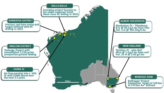
*An Exploration Target as defined in the JORC Code (2012) is a statement or estimate of the exploration potential of a mineral deposit in a defined geological setting where the statement or estimate, quoted as a range of tonnes and a range of grade (or quality), relates to mineralisation for which there has been insufficient exploration to estimate a Mineral Resource. Accordingly, these figures are not Mineral Resource or Ore Reserve estimates as defined in the JORC Code (2012). The potential quantities and grades referred to above are conceptual in nature and there has been insufficient exploration to estimate a Mineral Resource and it is uncertain if further exploration will result in the estimation of a Mineral Resource. These figures are based on the interpreted continuity of mineralisation and projection into unexplored ground often around historical workings. The Exploration Target has been prepared in accordance with the JORC Code (2012), as detailed in the Company’s ASX announcement released on 25 September 2024 (available to view at www.asx.com.au). The Tonnage range for the exploration target is 1.5Mt to 2.1Mt, the Grade range is 6.6g/t Au to 8.4g/t Au and the Ounces range from 320koz Au to 570 koz Au. The Company confirms that it is not aware of any new information that materially affects the information included in the original market announcement and that all material assumptions and technical parameters underpinning the estimates in the original market announcement continue to apply and have not materially changed. Dr Christopher Doyle (MAIG) and Dr Simon Dominy (FAusIMM CPGeo; FAIG RPGeo), are the qualified persons, as defined under National Instrument 43-101 Standards of Disclosure for Mineral Projects, responsible for, and having reviewed and approved, the technical information relating to the Exploration Target. Dr Doyle is Novo’s Exploration Manager - Victoria and Dr Dominy is a Technical Advisor to Novo.
#Refer to De Grey’s ASX Announcement, Hemi Gold Project mineral Resource Estimate (MRE) 2024, dated 14 November 2024. No assurance can be given that a similar (or any) commercially viable mineral deposit will be determined at Novo’s Pilbara Projects.
Appendix 1 –Table of Soil Sample Results, GDA94 z54 | ||||||
Sample ID | Sample Type | Year | Easting (m) | Northing (m) | Height (m) | Au (ppb) |
K00003 | Soil | 2025 | 584,379 | 6,725,360 | 191 | 20 |
K00005 | Soil | 2025 | 584,419 | 6,725,360 | 185 | 117 |
K00006 | Soil | 2025 | 584,440 | 6,725,359 | 185 | 291 |
K00007 | Soil | 2025 | 584,460 | 6,725,360 | 184 | 22 |
K00012 | Soil | 2025 | 584,559 | 6,725,359 | 189 | 15 |
K00023 | Soil | 2025 | 584,500 | 6,725,400 | 192 | 18 |
K00026 | Soil | 2025 | 584,441 | 6,725,399 | 192 | 29 |
K00027 | Soil | 2025 | 584,418 | 6,725,398 | 192 | 299 |
K00028 | Soil | 2025 | 584,401 | 6,725,400 | 190 | 38 |
K00029 | Soil | 2025 | 584,380 | 6,725,400 | 190 | 30 |
K00030 | Soil | 2025 | 584,359 | 6,725,400 | 189 | 16 |
K00031 | Soil | 2025 | 584,339 | 6,725,400 | 188 | 24 |
K00033 | Soil | 2025 | 584,400 | 6,725,480 | 190 | 23 |
K00034 | Soil | 2025 | 584,378 | 6,725,481 | 189 | 39 |
K00036 | Soil | 2025 | 584,360 | 6,725,479 | 188 | 31 |
K00037 | Soil | 2025 | 584,340 | 6,725,480 | 189 | 226 |
K00038 | Soil | 2025 | 584,320 | 6,725,480 | 188 | 40 |
K00039 | Soil | 2025 | 584,300 | 6,725,479 | 187 | 72 |
K00040 | Soil | 2025 | 584,279 | 6,725,479 | 187 | 21 |
K00041 | Soil | 2025 | 584,260 | 6,725,480 | 187 | 19 |
K00042 | Soil | 2025 | 584,238 | 6,725,479 | 187 | 21 |
K00046 | Soil | 2025 | 584,200 | 6,725,439 | 185 | 16 |
K00052 | Soil | 2025 | 584,320 | 6,725,439 | 190 | 137 |
K00053 | Soil | 2025 | 584,340 | 6,725,440 | 191 | 22 |
K00054 | Soil | 2025 | 584,361 | 6,725,439 | 190 | 24 |
K00055 | Soil | 2025 | 584,381 | 6,725,440 | 191 | 31 |
K00056 | Soil | 2025 | 584,401 | 6,725,440 | 192 | 154 |
K00057 | Soil | 2025 | 584,420 | 6,725,439 | 194 | 29 |
K00058 | Soil | 2025 | 584,441 | 6,725,440 | 195 | 32 |
K00075 | Soil | 2025 | 584,417 | 6,725,479 | 192 | 101 |
K00076 | Soil | 2025 | 584,440 | 6,725,519 | 191 | 178 |
K00077 | Soil | 2025 | 584,420 | 6,725,520 | 186 | 1,585 |
K00078 | Soil | 2025 | 584,406 | 6,725,520 | 185 | 848 |
K00079 | Soil | 2025 | 584,380 | 6,725,520 | 183 | 80 |
K00083 | Soil | 2025 | 584,240 | 6,725,520 | 179 | 19 |
K00084 | Soil | 2025 | 584,220 | 6,725,520 | 178 | 36 |
K00089 | Soil | 2025 | 584,321 | 6,725,560 | 177 | 15 |
K00090 | Soil | 2025 | 584,340 | 6,725,559 | 179 | 50 |
K00091 | Soil | 2025 | 584,360 | 6,725,558 | 180 | 286 |
K00093 | Soil | 2025 | 584,460 | 6,725,559 | 183 | 16 |
K00094 | Soil | 2025 | 584,480 | 6,725,559 | 183 | 35 |
K00102 | Soil | 2025 | 584,460 | 6,725,519 | 185 | 18 |
K00103 | Soil | 2025 | 584,301 | 6,725,640 | 185 | 112 |
K00104 | Soil | 2025 | 584,320 | 6,725,639 | 185 | 254 |
K00105 | Soil | 2025 | 584,341 | 6,725,640 | 186 | 188 |
K00106 | Soil | 2025 | 584,360 | 6,725,640 | 185 | 43 |
K00108 | Soil | 2025 | 584,400 | 6,725,639 | 187 | 16 |
K00113 | Soil | 2025 | 584,500 | 6,725,599 | 189 | 20 |
K00122 | Soil | 2025 | 584,361 | 6,725,600 | 187 | 40 |
K00123 | Soil | 2025 | 584,336 | 6,725,599 | 185 | 64 |
K00124 | Soil | 2025 | 584,321 | 6,725,600 | 190 | 21 |
K00125 | Soil | 2025 | 584,300 | 6,725,600 | 190 | 18 |
K00126 | Soil | 2025 | 584,280 | 6,725,599 | 189 | 62 |
K00127 | Soil | 2025 | 584,260 | 6,725,599 | 189 | 492 |
K00128 | Soil | 2025 | 584,240 | 6,725,600 | 188 | 38 |
K00129 | Soil | 2025 | 584,220 | 6,725,599 | 187 | 36 |
K00130 | Soil | 2025 | 584,220 | 6,725,639 | 187 | 15 |
K00131 | Soil | 2025 | 584,239 | 6,725,640 | 189 | 18 |
K00132 | Soil | 2025 | 584,260 | 6,725,640 | 191 | 29 |
K00133 | Soil | 2025 | 584,281 | 6,725,640 | 190 | 25 |
K00136 | Soil | 2025 | 584,439 | 6,725,680 | 197 | 31 |
K00138 | Soil | 2025 | 584,401 | 6,725,680 | 195 | 19 |
K00140 | Soil | 2025 | 584,361 | 6,725,680 | 192 | 18 |
K00141 | Soil | 2025 | 584,340 | 6,725,680 | 192 | 47 |
K00142 | Soil | 2025 | 584,319 | 6,725,677 | 192 | 1,440 |
K00143 | Soil | 2025 | 584,300 | 6,725,680 | 192 | 45 |
K00144 | Soil | 2025 | 584,276 | 6,725,679 | 191 | 20 |
K00149 | Soil | 2025 | 584,203 | 6,725,676 | 187 | 30 |
K00152 | Soil | 2025 | 584,160 | 6,725,759 | 184 | 17 |
K00153 | Soil | 2025 | 584,180 | 6,725,761 | 183 | 16 |
K00154 | Soil | 2025 | 584,240 | 6,725,759 | 182 | 21 |
K00155 | Soil | 2025 | 584,260 | 6,725,760 | 183 | 47 |
K00163 | Soil | 2025 | 584,420 | 6,725,760 | 186 | 29 |
K00168 | Soil | 2025 | 584,321 | 6,725,840 | 187 | 15 |
K00172 | Soil | 2025 | 584,220 | 6,725,840 | 185 | 23 |
K00176 | Soil | 2025 | 584,140 | 6,725,839 | 185 | 18 |
K00190 | Soil | 2025 | 584,221 | 6,725,920 | 187 | 51 |
K00223 | Soil | 2025 | 584,040 | 6,726,239 | 189 | 20 |
K00224 | Soil | 2025 | 584,060 | 6,726,240 | 189 | 21 |
K00239 | Soil | 2025 | 583,920 | 6,726,399 | 191 | 20 |
K00241 | Soil | 2025 | 583,880 | 6,726,399 | 191 | 25 |
K00253 | Soil | 2025 | 583,900 | 6,726,559 | 201 | 15 |
K00257 | Soil | 2025 | 583,820 | 6,726,559 | 205 | 15 |
K00258 | Soil | 2025 | 583,801 | 6,726,559 | 207 | 51 |
K00263 | Soil | 2025 | 583,701 | 6,726,560 | 198 | 23 |
K00268 | Soil | 2025 | 583,620 | 6,726,560 | 197 | 20 |
K00269 | Soil | 2025 | 583,600 | 6,726,560 | 196 | 24 |
K00274 | Soil | 2025 | 583,521 | 6,726,559 | 195 | 16 |
K00291 | Soil | 2025 | 584,361 | 6,725,880 | 189 | 19 |
K00306 | Soil | 2025 | 584,277 | 6,725,721 | 187 | 17 |
K00309 | Soil | 2025 | 584,340 | 6,725,720 | 186 | 16 |
K00322 | Soil | 2025 | 584,301 | 6,725,800 | 182 | 42 |
K00324 | Soil | 2025 | 584,200 | 6,725,800 | 183 | 22 |
K00333 | Soil | 2025 | 584,119 | 6,725,880 | 187 | 17 |
K00334 | Soil | 2025 | 584,141 | 6,725,880 | 186 | 21 |
K00338 | Soil | 2025 | 584,199 | 6,725,880 | 188 | 18 |
K00340 | Soil | 2025 | 584,239 | 6,725,880 | 188 | 20 |
K00354 | Soil | 2025 | 584,201 | 6,726,000 | 197 | 16 |
K00360 | Soil | 2025 | 583,900 | 6,726,160 | 183 | 15 |
K00451 | Soil | 2025 | 584,402 | 6,725,319 | 177 | 21 |
K00454 | Soil | 2025 | 584,461 | 6,725,320 | 179 | 75 |
K00455 | Soil | 2025 | 584,481 | 6,725,318 | 178 | 28 |
K00456 | Soil | 2025 | 584,500 | 6,725,320 | 181 | 21 |
K00479 | Soil | 2025 | 584,541 | 6,725,280 | 181 | 16 |
K00482 | Soil | 2025 | 584,482 | 6,725,280 | 177 | 19 |
K00499 | Soil | 2025 | 584,481 | 6,725,240 | 178 | 19 |
K00504 | Soil | 2025 | 584,460 | 6,725,719 | 190 | 55 |
K00506 | Soil | 2025 | 584,500 | 6,725,680 | 189 | 15 |
K00511 | Soil | 2025 | 584,520 | 6,725,599 | 182 | 18 |
K00512 | Soil | 2025 | 584,540 | 6,725,599 | 183 | 64 |
K00514 | Soil | 2025 | 584,579 | 6,725,560 | 186 | 17 |
K00528 | Soil | 2025 | 584,660 | 6,725,400 | 192 | 27 |
K00529 | Soil | 2025 | 584,640 | 6,725,400 | 193 | 31 |
K00539 | Soil | 2025 | 584,441 | 6,725,199 | 181 | 20 |
K00540 | Soil | 2025 | 584,461 | 6,725,200 | 181 | 15 |
K00550 | Soil | 2025 | 584,640 | 6,725,200 | 191 | 61 |
K00551 | Soil | 2025 | 584,660 | 6,725,200 | 190 | 16 |
K00567 | Soil | 2025 | 584,660 | 6,725,040 | 193 | 20 |
K00578 | Soil | 2025 | 584,860 | 6,725,039 | 190 | 32 |
K00601 | Soil | 2025 | 584,521 | 6,725,241 | 186 | 27 |
K00602 | Soil | 2025 | 584,541 | 6,725,240 | 188 | 15 |
K00611 | Soil | 2025 | 584,721 | 6,725,239 | 193 | 18 |
K00613 | Soil | 2025 | 584,425 | 6,725,160 | 186 | 22 |
K00614 | Soil | 2025 | 584,440 | 6,725,160 | 186 | 18 |
K00627 | Soil | 2025 | 584,660 | 6,725,161 | 187 | 26 |
K00658 | Soil | 2025 | 584,600 | 6,725,081 | 185 | 16 |
K00662 | Soil | 2025 | 584,680 | 6,725,080 | 185 | 32 |
K00663 | Soil | 2025 | 584,700 | 6,725,080 | 183 | 19 |
K00697 | Soil | 2025 | 583,520 | 6,726,720 | 197 | 16 |
K00708 | Soil | 2025 | 584,681 | 6,724,959 | 178 | 21 |
K00744 | Soil | 2025 | 584,701 | 6,724,802 | 178 | 26 |
K00762 | Soil | 2025 | 583,480 | 6,726,641 | 191 | 15 |
K00768 | Soil | 2025 | 583,580 | 6,726,640 | 192 | 24 |
K00772 | Soil | 2025 | 583,641 | 6,726,640 | 194 | 21 |
K00773 | Soil | 2025 | 583,661 | 6,726,640 | 196 | 18 |
K00800 | Soil | 2025 | 583,701 | 6,726,800 | 206 | 16 |
K00814 | Soil | 2025 | 583,599 | 6,726,960 | 189 | 19 |
K00846 | Soil | 2025 | 583,540 | 6,726,680 | 199 | 16 |
K00875 | Soil | 2025 | 583,740 | 6,726,881 | 201 | 15 |
K00888 | Soil | 2025 | 583,501 | 6,726,880 | 197 | 18 |
K00891 | Soil | 2025 | 583,442 | 6,726,880 | 193 | 48 |
K00896 | Soil | 2025 | 583,360 | 6,726,880 | 191 | 37 |
K00905 | Soil | 2025 | 583,620 | 6,726,600 | 204 | 22 |
K00953 | Soil | 2025 | 583,660 | 6,726,800 | 207 | 18 |
K00993 | Soil | 2025 | 583,440 | 6,726,840 | 193 | 18 |
K00994 | Soil | 2025 | 583,460 | 6,726,840 | 193 | 132 |
Appendix 2 –Table of Rock Sample Results, GDA94 z54 | ||||||
Sample ID | Sample Type | Year | Easting (m) | Northing (m) | Height (m) | Au g/t |
R08501 | Rock Chip | 2025 | 584,630 | 6,725,239 | 188 | 0.01 |
R08502 | Rock Chip | 2025 | 584,207 | 6,725,875 | 185 | 0.01 |
R08503 | Rock Chip | 2025 | 584,136 | 6,726,016 | 186 | <0.01 |
R08504 | Rock Chip | 2025 | 584,147 | 6,726,032 | 186 | <0.01 |
R08505 | Rock Chip | 2025 | 583,959 | 6,726,024 | 182 | <0.01 |
R08506 | Rock Chip | 2025 | 583,993 | 6,726,086 | 183 | 0.01 |
R08507 | Rock Chip | 2025 | 583,769 | 6,726,607 | 198 | <0.01 |
R08508 | Rock Chip | 2025 | 583,701 | 6,726,775 | 192 | <0.01 |
R08509 | Mullock Grab | 2025 | 583,636 | 6,726,526 | 193 | 0.01 |
R08510 | Rock Chip | 2025 | 583,637 | 6,726,527 | 192 | 0.03 |
R08512 | Rock Chip | 2025 | 583,652 | 6,726,499 | 193 | 0.01 |
R08513 | Rock Chip | 2025 | 583,645 | 6,726,507 | 192 | 0.01 |
R08514 | Rock Chip | 2025 | 583,538 | 6,726,696 | 192 | <0.01 |
R08516 | Rock Chip | 2025 | 583,471 | 6,726,830 | 190 | 0.08 |
R08517 | Rock Chip | 2025 | 583,412 | 6,726,966 | 187 | 0.02 |
R08518 | Rock Chip | 2025 | 584,942 | 6,726,444 | 203 | <0.01 |
R08519 | Rock Chip | 2025 | 584,886 | 6,726,665 | 210 | 0.01 |
R08520 | Rock Chip | 2025 | 584,269 | 6,725,573 | 183 | 0.04 |
R08521 | Rock Chip | 2025 | 584,271 | 6,725,573 | 182 | 0.02 |
R08522 | Rock Chip | 2025 | 584,274 | 6,725,576 | 183 | 0.02 |
R08523 | Rock Chip | 2025 | 584,254 | 6,725,619 | 182 | 0.01 |
R08524 | Mullock Grab | 2025 | 584,297 | 6,725,573 | 185 | 0.01 |
R08525 | Rock Chip | 2025 | 584,299 | 6,725,575 | 184 | 0.03 |
R08527 | Mullock Grab | 2025 | 584,285 | 6,725,724 | 185 | 0.02 |
R08528 | Rock Chip | 2025 | 584,292 | 6,725,735 | 183 | 0.01 |
R08529 | Rock Chip | 2025 | 584,284 | 6,725,730 | 183 | 0.01 |
R08530 | Rock Chip | 2025 | 584,286 | 6,725,731 | 183 | 0.03 |
R08531 | Mullock Grab | 2025 | 584,309 | 6,725,703 | 183 | 89.6 |
R08532 | Mullock Grab | 2025 | 584,313 | 6,725,690 | 184 | 41.9 |
R08533 | Mullock Grab | 2025 | 584,327 | 6,725,670 | 184 | 1.03 |
R08534 | Mullock Grab | 2025 | 584,330 | 6,725,669 | 184 | 1.7 |
R08536 | Rock Chip | 2025 | 584,345 | 6,725,654 | 184 | 7.72 |
R08537 | Rock Chip | 2025 | 584,351 | 6,725,649 | 183 | 4.01 |
R08538 | Rock Chip | 2025 | 584,356 | 6,725,603 | 187 | 3.88 |
R08539 | Mullock Grab | 2025 | 584,370 | 6,725,586 | 187 | 2.38 |
R08540 | Rock Chip | 2025 | 584,366 | 6,725,588 | 185 | 1.84 |
R08541 | Rock Chip | 2025 | 584,364 | 6,725,588 | 185 | 1.5 |
R08542 | Rock Chip | 2025 | 584,361 | 6,725,588 | 186 | 0.84 |
R08543 | Rock Chip | 2025 | 584,362 | 6,725,586 | 186 | 0.15 |
R08544 | Rock Chip | 2025 | 584,376 | 6,725,568 | 184 | 4.79 |
R08545 | Rock Chip | 2025 | 584,376 | 6,725,568 | 184 | 0.24 |
R08546 | Rock Chip | 2025 | 584,375 | 6,725,569 | 184 | 2.5 |
R08547 | Rock Chip | 2025 | 584,375 | 6,725,569 | 184 | 0.14 |
R08548 | Rock Chip | 2025 | 584,375 | 6,725,569 | 184 | 0.45 |
R08549 | Rock Chip | 2025 | 584,373 | 6,725,569 | 184 | 31.4 |
R08551 | Rock Chip | 2025 | 584,377 | 6,725,568 | 183 | 0.48 |
R08552 | Rock Chip | 2025 | 584,370 | 6,725,575 | 183 | 0.33 |
R08553 | Rock Chip | 2025 | 584,369 | 6,725,575 | 183 | 10.4 |
R08554 | Rock Chip | 2025 | 584,368 | 6,725,574 | 183 | 0.3 |
R08555 | Rock Chip | 2025 | 584,368 | 6,725,573 | 183 | 0.57 |
R08556 | Mullock Grab | 2025 | 584,468 | 6,725,586 | 186 | 0.08 |
R08557 | Rock Chip | 2025 | 584,476 | 6,725,589 | 187 | 0.04 |
R08558 | Rock Chip | 2025 | 584,473 | 6,725,587 | 187 | 0.03 |
R08559 | Rock Chip | 2025 | 584,401 | 6,725,519 | 188 | 4.91 |
R08561 | Rock Chip | 2025 | 584,400 | 6,725,518 | 188 | 0.44 |
R08562 | Rock Chip | 2025 | 584,400 | 6,725,518 | 188 | 2.32 |
R08563 | Rock Chip | 2025 | 584,407 | 6,725,506 | 198 | 0.09 |
R08564 | Rock Chip | 2025 | 584,399 | 6,725,518 | 188 | 0.12 |
R08565 | Rock Chip | 2025 | 584,490 | 6,725,541 | 199 | 0.02 |
R08566 | Mullock Grab | 2025 | 584,432 | 6,725,455 | 199 | 0.03 |
R08567 | Rock Chip | 2025 | 584,652 | 6,725,152 | 202 | 0.01 |
R08568 | Rock Chip | 2025 | 584,654 | 6,725,147 | 200 | 0.02 |
R08569 | Rock Chip | 2025 | 584,663 | 6,725,136 | 201 | 0.01 |
R08570 | Rock Chip | 2025 | 584,673 | 6,725,111 | 199 | <0.01 |
R08571 | Rock Chip | 2025 | 584,439 | 6,725,717 | 194 | 0.01 |
R08572 | Rock Chip | 2025 | 584,477 | 6,725,594 | 187 | 0.02 |
R08573 | Rock Chip | 2025 | 584,277 | 6,725,409 | 182 | 0.02 |
R08574 | Rock Chip | 2025 | 584,347 | 6,725,438 | 185 | <0.01 |
R08575 | Mullock Grab | 2025 | 584,416 | 6,725,394 | 186 | 0.19 |
R08576 | Mullock Grab | 2025 | 584,474 | 6,725,305 | 185 | 0.23 |
R08577 | Rock Chip | 2025 | 584,508 | 6,725,474 | 192 | <0.01 |
R08578 | Rock Chip | 2025 | 584,230 | 6,725,586 | 188 | <0.01 |
R08579 | Rock Chip | 2025 | 584,755 | 6,724,894 | 190 | <0.01 |
R08580 | Rock Chip | 2025 | 584,728 | 6,724,883 | 189 | <0.01 |
R08601 | Rock Chip | 2025 | 585,409 | 6,725,033 | 190 | <0.01 |
R08602 | Rock Chip | 2025 | 585,433 | 6,724,539 | 171 | <0.01 |
JORC Code, 2012 Edition – Table 1
Section 1: Sampling Techniques and Data
(Criteria listed in the preceding section also apply to this section)
Criteria | JORC Code explanation | Commentary |
Sampling techniques |
|
|
Drilling techniques |
|
|
Drill sample recovery |
|
|
Logging |
|
|
Sub-sampling techniques and sample preparation |
|
|
Quality of assay data and laboratory tests |
|
|
Verification of sampling and assaying |
|
|
Location of data points |
|
|
Data spacing and distribution |
|
|
Orientation of data in relation to geological structure |
|
|
Sample security |
|
|
Audits or reviews |
|
|
Section 2: Reporting of Exploration Results
(Criteria listed in the preceding section also apply to this section)
Criteria | JORC Code explanation | Commentary |
Mineral tenement and land tenure status |
|
|
Exploration done by other parties |
|
|
Geology |
|
|
Drill hole Information |
|
|
Data aggregation methods |
|
|
Relationship between mineralisation widths and intercept lengths |
|
|
Diagrams |
|
|
Balanced reporting |
|
|
Other substantive exploration data |
|
|
Further work |
|
|
No Section 3 or 4 report as no Mineral Resources or Ore Reserves are reported in this Appendix
__________________
3 Refer to ASX news release by Novo Resources dated 16/12/2024 – Novo Strengthens Portfolio with Two High-Grade Gold Projects in NSW, Australia
Photos accompanying this announcement are available at
https://www.globenewswire.com/NewsRoom/AttachmentNg/540ec385-0b56-4930-9955-d918c15766e2
https://www.globenewswire.com/NewsRoom/AttachmentNg/1256943b-c790-4d1b-bfa3-653e664b92f0
https://www.globenewswire.com/NewsRoom/AttachmentNg/0829898f-fad0-4e99-84f4-c7018ea24d34
https://www.globenewswire.com/NewsRoom/AttachmentNg/2d4edc6c-d557-4e05-800c-aea39ffbe737
https://www.globenewswire.com/NewsRoom/AttachmentNg/3656539e-4794-4c59-9471-98604893f417
https://www.globenewswire.com/NewsRoom/AttachmentNg/8429e080-cfc2-4804-8710-bc4eef98d0a3
https://www.globenewswire.com/NewsRoom/AttachmentNg/af0bed22-4da7-4ac2-84c9-11251ea8e4e3
https://www.globenewswire.com/NewsRoom/AttachmentNg/a62ccce8-36d9-40ec-ad26-93c866d86068