
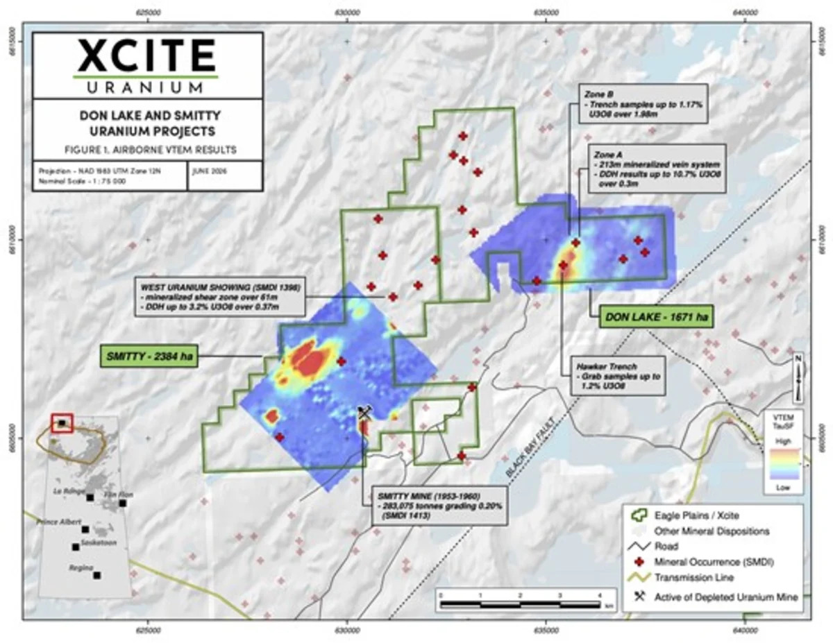
Vancouver, British Columbia--(Newsfile Corp. - June 25, 2026) - Xcite Uranium Inc. (CSE: XRI) ("XRI", "Xcite" or the "Company"), is pleased to announce initial geophysical results from a 2025 VTEM Plus airborne geophysical survey carried out by Geotech Airborne Geophysical Surveys that covered the Don Lake (1671ha), and Smitty (2384) uranium projects. Advanced geophysical interpretation and modeling by Condor Consulting Inc. is nearing completion and will aid in prioritizing areas for summer fieldwork and targeting drill holes in Q3/Q4 2026.
The Calculated Vertical Gradient (CVG) (Figure 1) shows both magnetic high and low features aligned parallel to the regional Black Bay Fault, one of the main controlling structures for uranium mineralization in the Beaverlodge camp. At Don Lake, there is a pronounced high electromagnetic (EM) conductivity feature (Figure 2) associated with the Zone A, Zone B and Hawker Trench uranium occurrences, which also lie along a mag high and mag low break. At the Smitty project, the historic Smitty mine is associated with an EM conductor high. An additional high conductivity feature located in the western part of the property is also prospective and will be evaluated during the summer 2026 field program.
The 2025 VTEM Plus airborne geophysical survey covered the six uranium projects and the survey data was merged with publicly available geophysical data collected by previous operators.
The Don Lake and Smitty uranium projects are located near Uranium City, Saskatchewan, and host near surface uranium mineralization as well as past producing uranium mines.
XRI Compilation Geophysics map - Figure 1. Magnetics
To view an enhanced version of this graphic, please visit:
https://images.newsfilecorp.com/files/8603/302868_figure1.jpg
XRI Compilation Geophysics map - Figure 2. Conductivity
To view an enhanced version of this graphic, please visit:
https://images.newsfilecorp.com/files/8603/302868_ec8eee7b2488cbf9_001full.jpg
Project Highlights
Don Lake
Twelve SMDI uranium occurrences
Historical drilling at A Zone returned values of 10.7% U3O8 over 0.3m and 2.14% U3O8 over 0.67m
Trench samples up to 1.17% U3O8 over 1.98m
Smitty
Eleven SMDI uranium occurrences
Host to the past producing Smitty Mine
Historical drilling at West Uranium Showing returned up to 3.2% U3O8 0ver 0.37m
To view an enhanced version of this graphic, please visit:
https://images.newsfilecorp.com/files/8603/302868_figure3.jpg
The Uranium City projects are included in a formal Exploration Agreement between Eagle Plains and the Ya'thi Néné Lands and Resource Office ("YNLR"), representing the Athabasca Denesułiné First Nations of Hatchet Lake, Black Lake, and Fond du Lac, the Northern Hamlet of Stony Rapids, and the Northern Settlements of Uranium City, Wollaston Lake and Camsell Portage.