Third Rig at Eastmain, Mineralised Tonalite at E Zone
HIGHLIGHTS
Third drill rig on site adding to the two already in operation at Eastmain
Drilling capacity increased to c.1,500m/week - 38,000m drilled to date, on track to achieve the 2021 plan of 50,000m
Drilling targeting DHEM conductors down-plunge of A and C Zones and extensions to E Zone
Over 15,000 samples from 52 drillholes awaiting assays
New style of mineralisation discovered at E Zone associated with a tonalite intrusion located structurally between the Kotak and Mine trend with visible gold observed
Toronto, Ontario--(Newsfile Corp. - October 20, 2021) - Benz Mining Corp. (TSXV: BZ) (ASX: BNZ) (the Company or Benz) is pleased to provide an update on its 2021 drilling campaign. The third drill rig, originally booked for September, is now on site at Eastmain and drilling electromagnetic targets down-plunge from the existing resource.
CEO, Xavier Braud, commented: "The third rig we needed to accelerate our drilling program is now in operation at Eastmain. Our current drilling capacity has increased to ~1,500m per week which will see us achieve our original target of 50,000m of drilling this year. We currently have over 15,000 samples awaiting assay results. Turnaround time at the laboratory has been extremely slow especially with the need for metallic screen fire assays. The discovery of a new mineralised system with visible gold at E Zone is also very exciting and we look forward to sharpening our understanding of this new fertile system. Eastmain is still surprising us which augurs very well for the future."
Figure 1: Eastmain Gold Project with 2021 drillholes pending assays, 2021 drilling with logged visible gold, DHEM conductors modelled to date and current drill rig location
Figure 2: Map view of the Eastmain Project with historical and current high grade drill results and 2021 drilling pending assays with EM conductors and simplified geology
At E Zone, drilling encountered a tonalite intrusion structurally located between the Kotak horizon and the Mine horizon.
This tonalite has a variable thickness over the area.
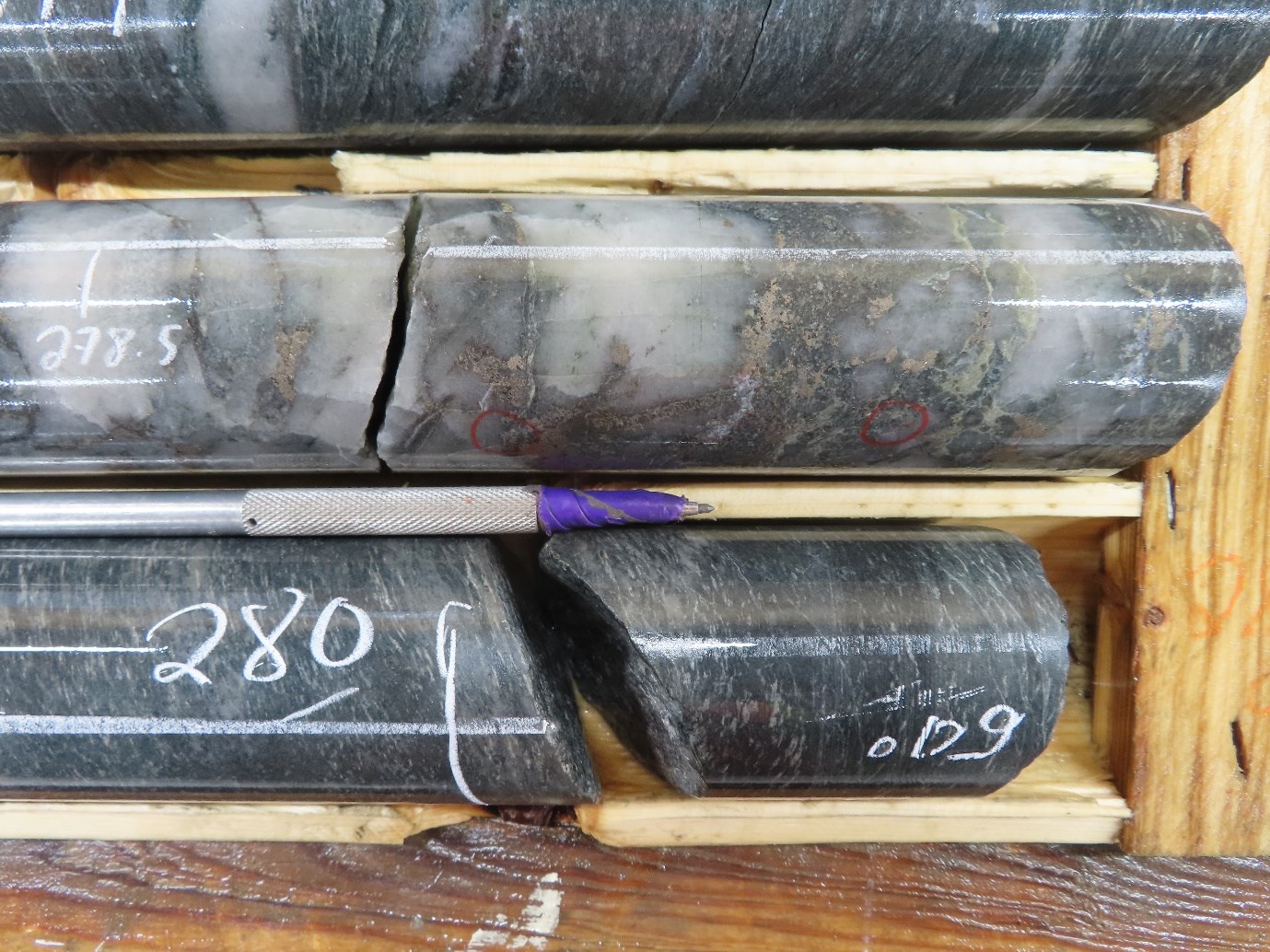
The tonalite shows numerous zones of alteration with silicification, sericitization and albitisation. Quartz veins are present with associated tourmaline and carbonate.
The tonalite also shows sulphide mineralisation as disseminations in the veins and on their margins. Sulphides include pyrite, pyrrhotite and chalcopyrite with occasional sphalerite and molybdenite. Garnet porphyroblasts are observed in the strongest alteration zones. Sulphide mineralisation coincides broadly with the conductors identified by downhole EM.
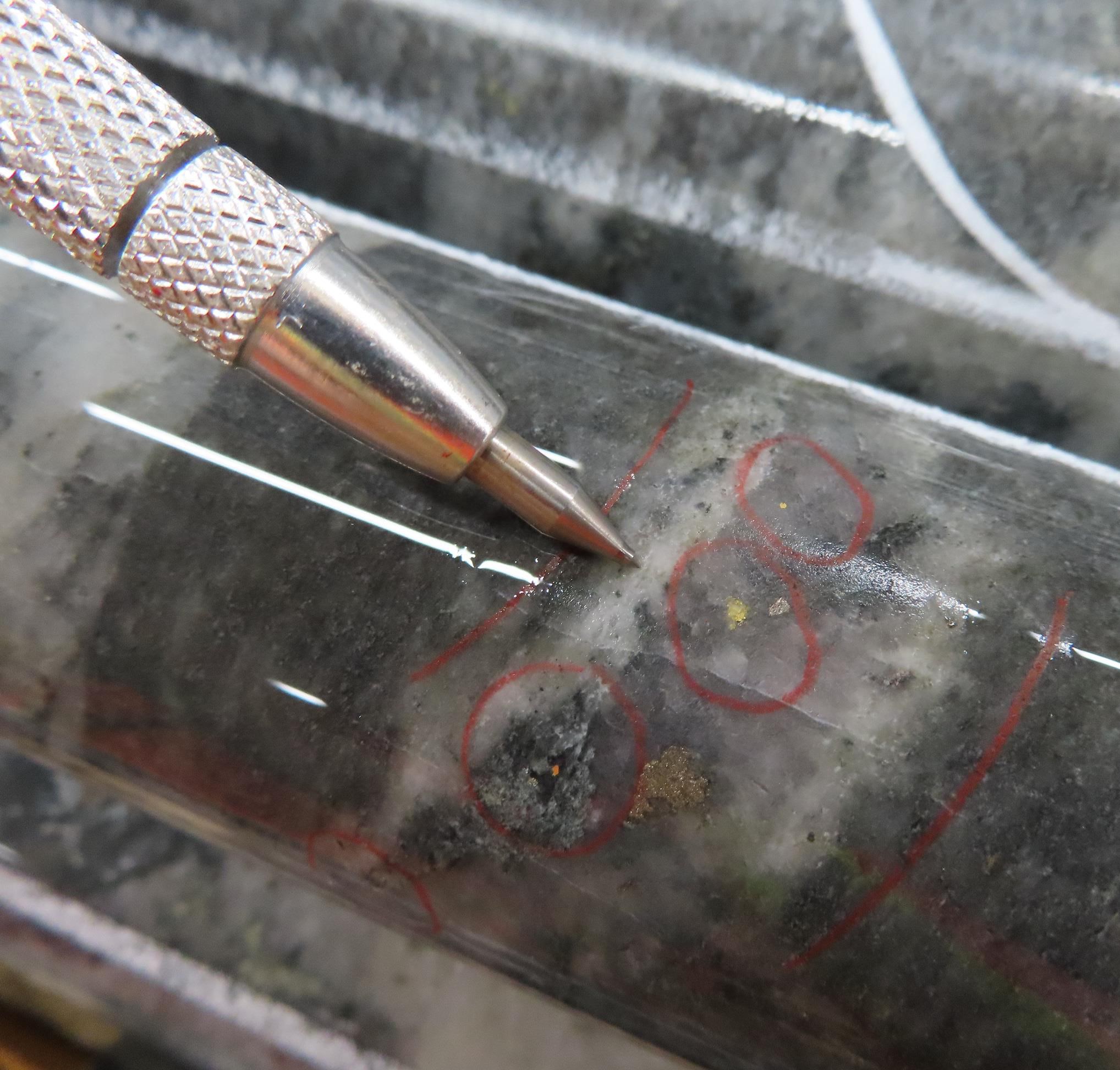
Quartz veins with carbonate within the tonalite contain visible gold.
Visible gold was also observed in the upper sheared contact between the tonalite and the overlying alternation of volcanics and ultramafics.
Figure 3: NE-SW Schematic geological cross section showing the newly discovered mineralised tonalite intrusion at E Zone
Figure 5:Mineralised vein is hosted in a moderately biotitized, silicified and albitized tonalite with tourmaline-quartz carbonate veins and local garnet porphyroblasts. (Hole EM21-207, 342.2m)
Drilling of DHEM conductors down-plunge from A and C Zones show that the mineralised system carries out at depth. The current drilling in those areas follows the same methodology applied by Benz in the last 12 months at Eastmain with 100m step-outs. Whilst this spacing is too wide to establish a resource estimate from the current drilling, it gives the Company a much better understanding of the potential footprint of the deposit before planning infill drilling.
Figure 6: C Zone depth extension (EM21-205, 601.0m)
The Eastmain Gold Project, situated on the Upper Eastmain Greenstone Belt in Quebec, Canada, currently hosts a NI 43-101 and JORC (2012) compliant resource of 376,000oz at 7.9gpt gold (Indicated: 236,500oz at 8.2gtp gold, Inferred: 139,300oz at 7.5gtp gold). The existing gold mineralisation is associated with 15-20% semi-massive to massive pyrrhotite, pyrite and chalcopyrite in highly deformed and altered rocks making it amenable to detection using electromagnetic techniques. Multiple gold occurrences have been identified by previous explorers over a 10km long zone along strike from the Eastmain Mine with very limited but highly encouraging testing outside the existing resource area. Benz has subsequently identified over 150 DHEM conductors over a strike length of 6km which is open in all directions.
This press release was prepared under supervision and approved by Dr. Danielle Giovenazzo, P.Geo, acting as Benz's qualified person under National Instrument 43-101.
About Benz Mining Corp.
Benz Mining Corp. brings together an experienced team of geoscientists and finance professionals with a focused strategy to acquire and develop mineral projects with an emphasis on safe, low risk jurisdictions favourable to mining development. Benz is earning a 100% interest in the former producing high grade Eastmain gold mine, Ruby Hill West and Ruby Hill East projects in Quebec.
The Eastmain Gold Project is situated within the Upper Eastmain Greenstone Belt in Quebec, Canada and currently hosts a NI 43-101 and JORC (2012) compliant resource of 376,000oz at 7.9gpt gold. The existing gold mineralization is associated with 15-20% semi-massive to massive pyrrhotite, pyrite and chalcopyrite making it amenable to detection by electromagnetics. Several gold mineralization occurrences have been identified by previous explorers over a 10km long zone along strike from the Eastmain Mine with very limited testing outside the existing resource area.
Figure 8: Benz tenure over Upper Eastmain Greenstone Belt simplified geology.
On behalf of the Board of Directors of Benz Mining Corp.
Xavier Braud, CEO
For more information please contact:
Paul Fowler Head of Corporate Development (Canada) Benz Mining Corp. Telephone: +1 416 356 8165 Email: info@benzmining.com
Xavier Braud CEO, Head of Corporate Development (Aus) Benz Mining Corp. Telephone +61 423 237 659 Email: info@benzmining.com
Forward-Looking Information: Certain statements contained in this news release may constitute "forward-looking information" as such term is used in applicable Canadian securities laws. Forward-looking information is based on plans, expectations and estimates of management at the date the information is provided and is subject to certain factors and assumptions, including, that the Company's financial condition and development plans do not change as a result of unforeseen events and that the Company obtains regulatory approval. Forward-looking information is subject to a variety of risks and uncertainties and other factors that could cause plans, estimates and actual results to vary materially from those projected in such forward-looking information. Factors that could cause the forward-looking information in this news release to change or to be inaccurate include, but are not limited to, the risk that any of the assumptions referred to prove not to be valid or reliable, that occurrences such as those referred to above are realized and result in delays, or cessation in planned work, that the Company's financial condition and development plans change, and delays in regulatory approval, as well as the other risks and uncertainties applicable to the Company as set forth in the Company's continuous disclosure filings filed under the Company's profile at www.sedar.com. The Company undertakes no obligation to update these forward-looking statements, other than as required by applicable law.
NEITHER THE TSX VENTURE EXCHANGE NOR ITS REGULATION SERVICES PROVIDER (AS THAT TERM IS DEFINED IN THE POLICIES OF THE TSX VENTURE EXCHANGE) ACCEPTS RESPONSIBILITY FOR THE ACCURACY OR ADEQUACY OF THIS RELEASE.
Competent Person's Statements: The information in this report that relates to Exploration Results is based on and fairly represents information and supporting information compiled by Mr Xavier Braud, who is a member of the Australian Institute of Geoscientists (AIG membership ID:6963). Mr Braud is a consultant to the Company and has sufficient experience in the style of mineralization and type of deposits under consideration and qualifies as a Competent Person as defined in the 2012 edition of the "Australasian Code for Reporting of Exploration Results, Mineral Resources and Ore Reserves". Mr Braud holds securities in Benz Mining Corp and consents to the inclusion of all technical statements based on his information in the form and context in which they appear.
The information in this announcement that relates to the Inferred Mineral Resource was first reported under the JORC Code by the Company in its prospectus released to the ASX on 21 December 2020. The Company confirms that it is not aware of any new information or data that materially affects the information included in the original market announcement and confirms that all material assumptions and technical parameters underpinning the estimate continue to apply and have not materially changed. The Company confirms that the form and context in which the Competent Person's findings are presented have not been materially modified from the original market announcement.
Appendix 1: Collar Table 2021 Drilling
DDH ID
X_NAD83_Z18N
Y_NAD83_Z18N
Elevation
Azimuth (planned)
Azimuth (measured)
Dip planned
Dip (measured)
Planned Depth
Total Drilled length
EM21-143
698713
5798618
485.0
215
215.35
-56.9
56.92
550
567
EM21-144
698568
5799058
485
215
215.1
-75
75
450
477
EM21-145
698315
5799210
487
215
215.3
-60
60
350
333
EM21-146
698280
5799265
495
215
215
-60
60
350
297
EM21-147
698184
5799041
490
220
220
-55
55
200
225
EM21-148
698192
5799167
491
220
220
-60
55
265
265
EM21-149
698014
5799532
487
217
217
-55
54.9
220
225
EM21-150
698182
5799743
510
217
217.1
-55
54.9
165
201
EM21-151
698569
5798713
483
216
216.19
-60
60.4
620
657
EM21-152
699236
5798936
508
225
225
-75
74.9
600
636
EM21-153
699248
5798810
480
225
225.3
-80
80.5
620
619.3
EM21-154
699247
5799006
484
225
225.16
-75
75
610
675
EM21-155
698518
5798790
486
220
219.88
-60
60.4
575
585
EM21-156
698582
5799177
485
215
215.04
-75
75.3
450
507
EM21-157
698434
5799154
485
240
239.9
-60
58
450
471
EM21-158
698405
5799250
483
245
249
-60
59
600
648
EM21-159
698520
5799290
484
245
244.5
-65
-64.9
450
450
EM21-160
700655
5797357
503
215
214.66
-70
-70.4
450
477
EM21-161
701002
5797424
499
215
214.9
-60
-60.2
300
351
EM21-162
700174
5798070
488
210
210.4
-65
-65.3
550
651
EM21-163
701190
5797310
509
215
215.3
-60
-60
300
201
EM21-164
701030
5797282
524
210
210.4
-60
-60.2
200
273
EM21-165
700394
5798111
487
210
-74
-73.9
800
783
EM21-166
701160
5797442
494
215
214.9
-60
-60.6
380
411
EM21-167
701401
5797480
503
180
180.1
-70
-70.2
360
468
EM21-168
700280
5798134
485
210
210.3
-75
-75
680
687
EM21-169
701246
5797779
490
210
209.6
-75
-74.6
450
621
EM21-170
700276
5797965
490
210
210.3
-70
-70.4
600
636
EM21-171
700171
5797963
489
210
210
-70
-70.3
525
567
EM21-172
700605
5797443
495
210
209.9
-60
-60
450
453
EM21-173
700297
5797805
492
210
204.3
-70
-71
460
463
EM21-174
701371
5798073
484
210
209.65
-65
-65.3
800
781.45
EM21-175
700226
5797876
487
206
207.71
-70
-70
550
573
EM21-176
701210
5798045
483
213
212.8
-67
-67
610
624
EM21-177
700114
5797875
486
210
209.9
-70
-70.1
465
471
EM21-178
700263
5798666
481
215
215.3
-65
-65
600
603
EM21-179
700062
5797789
485
210
209.9
-70
-70.1
400
444
EM21-180
700357
5798529
482
210
210.1
-70
-70.5
650
648
EM21-181
700181
5797790
487
210
209.9
-65
-65.2
490
486
EM21-182
700341
5798224
484
210
209.9
-75
-75.2
700
780
EM21-183
700080
5798025
485
210
209.8
68
-67
600
669
EM21-184
700368
5797902
491
210
210.2
-70
-70.1
600
573
EM21-185
700305
5798405
486
210
209.47
-70
-70.02
800
804
EM21-186
700262
5797716
494
210
209.5
-70
-70.1
420
474
EM21-187
700428
5798232
487
210
205.65
-75
-75.2
780
831
EM21-188
700188
5797587
492
210
-70
-70.1
380
342
EM21-189
700039
5797566
495
210
209.45
-70
-69.94
350
309
EM21-190
700675
5797450
497
210
210.7
-65
-65.88
450
474
EM21-191
700474
5798085
492
210
208.3
-70
-69.83
680
696
EM21-192
701121
5797475
504
215
215
-60
-59.9
380
429
EM21-193
701204
5797420
494
215
215.2
-60
-59.9
430
420
EM21-194
700230
5798513
490
210
209.7
-70
-70.1
800
837
EM21-195
701352
5797496
500
185
184.8
-70
-70.1
460
513
EM21-196
701352
5797496
500
215
215.4
-60
-59.7
750
750
EM21-197
700253
5798660
479
200
196.7
-82
-83
550
798
EM21-198
701457
5797479
505
185
185.4
-70
-70.4
550
591
EM21-199
699463
5798380
480
215
214.7
-70
-69.9
650
720
EM21-200
701470
5797599
513
185
184.83
-70
-69.9
550
654
EM21-201
699599
5798581
484
210
209.6
-70
-70
750
816
EM21-202
701389
5797381
502
185
184.9
-70
-70
450
528
EM21-203
699776
5798523
483
215
215.1
-70
-70.1
670
627
EM21-204-B
699141
5799038
487
215
215.4
-70
-70.1
600
711
EM21-205
699783
5798534
482
215
214.9
-80
-79.9
700
693
EM21-206
701545
5797486
513
185
185.1
-70
-69.9
550
600
EM21-207
701411
5797582
505
185
N/A
-70
N/A
480
591
EM21-208
699050
5799080
493
215
215.89
-70
-70.28
650
588
EM21-209
699735
5798655
482
215
215.7
-75
-75.02
650
741
EM21-210
701222
5797541
503
215
214.33
-65
-65.51
500
510
EM21-211
699095
5798740
485
220
220.91
-70
-69.92
500
471
EM21-212
699647
5798671
477
215
N/A
-70
N/A
700
In progress
EM21-213
700971
5797181
531
215
215.05
-60
-60.1
300
In progress
EM21-214
699169
5798821
481
220
219.8
-70
-69.8
550
In progress
Appendix 2: JORC Tables
Section 1 Sampling Techniques and Data
(Criteria in this section apply to all succeeding sections.)
Criteria
JORC Code explanation
Commentary
Sampling techniques
Nature and quality of sampling (eg cut channels, random chips, or specific specialised industry standard measurement tools appropriate to the minerals under investigation, such as down hole gamma sondes, or handheld XRF instruments, etc). These examples should not be taken as limiting the broad meaning of sampling.
Include reference to measures taken to ensure sample representivity and the appropriate calibration of any measurement tools or systems used.
Aspects of the determination of mineralisation that are Material to the Public Report.
In cases where 'industry standard' work has been done this would be relatively simple (eg 'reverse circulation drilling was used to obtain 1 m samples from which 3 kg was pulverised to produce a 30 g charge for fire assay'). In other cases more explanation may be required, such as where there is coarse gold that has inherent sampling problems. Unusual commodities or mineralisation types (eg submarine nodules) may warrant disclosure of detailed information.
NQ size core drilling
This release does not include analytical results
Qualitative observations only
Drilling techniques
Drill type (eg core, reverse circulation, open-hole hammer, rotary air blast, auger, Bangka, sonic, etc) and details (eg core diameter, triple or standard tube, depth of diamond tails, face-sampling bit or other type, whether core is oriented and if so, by what method, etc).
Triple tube NQ core drilling.
Hole depths vary between 201m and 675m
Core was oriented using downhole orientation tool
Drill sample recovery
Method of recording and assessing core and chip sample recoveries and results assessed.
Measures taken to maximise sample recovery and ensure representative nature of the samples.
Whether a relationship exists between sample recovery and grade and whether sample bias may have occurred due to preferential loss/gain of fine/coarse material.
Core recoveries are routinely measured by comparing the length of core recovered against the length of drill rods used and recorded by the drilling contractor.
For sampled intervals the core is cut in half and half of the core is sent for assays whilst the other half of the core is retained in the core tray for future reference
Length of core sampled for individual assays is determined by the logging geologist following geological/mineralisation boundaries
To ensure representativity, no intervals shorter than 50cm are sampled.
Logging
Whether core and chip samples have been geologically and geotechnically logged to a level of detail to support appropriate Mineral Resource estimation, mining studies and metallurgical studies.
Whether logging is qualitative or quantitative in nature. Core (or costean, channel, etc) photography.
The total length and percentage of the relevant intersections logged.
All core is logged for
Lithology
Alteration
Mineralisation
Mineral species abundance
Veining
Structures
Both qualitative and quantitative logging is routinely conducted
100% of the core drilled is logged
Sub-sampling techniques and sample preparation
If core, whether cut or sawn and whether quarter, half or all core taken.
If non-core, whether riffled, tube sampled, rotary split, etc and whether sampled wet or dry.
For all sample types, the nature, quality and appropriateness of the sample preparation technique.
Quality control procedures adopted for all sub-sampling stages to maximise representivity of samples.
Measures taken to ensure that the sampling is representative of the in situ material collected, including for instance results for field duplicate/second-half sampling.
Whether sample sizes are appropriate to the grain size of the material being sampled.
Half core sampled
Quality of assay data and laboratory tests
The nature, quality and appropriateness of the assaying and laboratory procedures used and whether the technique is considered partial or total.
For geophysical tools, spectrometers, handheld XRF instruments, etc, the parameters used in determining the analysis including instrument make and model, reading times, calibrations factors applied and their derivation, etc.
Nature of quality control procedures adopted (eg standards, blanks, duplicates, external laboratory checks) and whether acceptable levels of accuracy (ie lack of bias) and precision have been established.
Most samples are submitted for Gold assay by Fire assay and AA (Atomic Absorption) of a 50g pulverized sample with gravimetic determination if >10 g/t.
Samples where visual observations suggested potential high grade gold and samples with visible gold are routinely submitted for metallic screen fire assays.
At this stage, no studies have been finalized on the repartition and size of the gold grains in the system, however visual observations of gold grains larger than 0.5mm suggest that fire assays should be considered a partial method at this stage
Coarse rejects samples will be analysed as duplicates using PhotonAssay
Verification of sampling and assaying
The verification of significant intersections by either independent or alternative company personnel.
The use of twinned holes.
Documentation of primary data, data entry procedures, data verification, data storage (physical and electronic) protocols.
Discuss any adjustment to assay data.
No twinning of holes at this stage
All sampling protocols have been peer reviewed and all data is stored appropriately
No adjustments to assay data have taken place.
Location of data points
Accuracy and quality of surveys used to locate drill holes (collar and down-hole surveys), trenches, mine workings and other locations used in Mineral Resource estimation.
Specification of the grid system used.
Quality and adequacy of topographic control.
All drillhole locations have been surveyed by handheld GPS with a typical accuracy of +/-4m
Downhole surveys are conducted using a Reflex Multishot Gyro or an Axis North Seeking Gyro.
Grid: UTM NAD83 Zone 18N
Topographic control is cross-checked with a 2013 LIDAR survey
Data spacing and distribution
Data spacing for reporting of Exploration Results.
Whether the data spacing and distribution is sufficient to establish the degree of geological and grade continuity appropriate for the Mineral Resource and Ore Reserve estimation procedure(s) and classifications applied.
Whether sample compositing has been applied.
All drilling conducted by Benz Mining in 2020 and 2021 is wide spaced and exploratory in nature.
Spacing between drillholes is typically 100m which is insufficient for resource estimation
Orientation of data in relation to geological structure
Whether the orientation of sampling achieves unbiased sampling of possible structures and the extent to which this is known, considering the deposit type.
If the relationship between the drilling orientation and the orientation of key mineralised structures is considered to have introduced a sampling bias, this should be assessed and reported if material.
Drilling targeted newly identified areas in the geological system. All drilling is oriented towards the SW. As some mineralisation at the project is seemingly dipping toward the NE the orientation of sampling should not introduce a bias in the samples.
Sample security
The measures taken to ensure sample security.
All samples are routinely cut and prepared on site by company employees and contractors.
Samples bags are sealed and transported to the laboratory directly from the sampling site by specialized transport companies.
Audits or reviews
The results of any audits or reviews of sampling techniques and data.
The Company is constantly reviewing its sampling and assaying policies. No external audit has been conducted at this stage.
Section 2 Reporting of Exploration Results
(Criteria listed in the preceding section also apply to this section.)
Criteria
JORC Code explanation
Commentary
Mineral tenement and land tenure status
Type, reference name/number, location and ownership including agreements or material issues with third parties such as joint ventures, partnerships, overriding royalties, native title interests, historical sites, wilderness or national park and environmental settings.
The security of the tenure held at the time of reporting along with any known impediments to obtaining a licence to operate in the area.
The Eastmain Mine Project comprises 152 contiguous mining claims each with an area of approximately 52.7 ha covering a total of 8,014.36 ha plus one industrial lease permit that are owned by Eastmain Mines Inc., a wholly owned subsidiary of Fury Gold Mines. The claims are numbered 1133433 to 1133583 consecutively plus claim 104458 (Figure 4.2). All of the claims are located within NTS sheet 33A 08.
The former Mine Lease BM 817 was issued on January 10, 1995 and expired in 2015 after a 20-year term. This former Mine Lease was converted to Industrial Lease 00184710000 on September 1, 2015 and contains all normal surface rights. The former mineral rights for BM 817 are now included in the expanded Claims 1133523, 1133524, 1133525, 1133505, 1133506 and 1133507.
The claims are 100% held by Fury Gold Mines subject to certain net smelter royalties ("NSR").
On August 9, 2019, Benz Mining Corp. announced that it has entered into an option agreement with Eastmain Resources Inc. (now Fury Gold Mines) to acquire a 100% interest in the former producing Eastmain Gold Project located in James Bay District, Quebec, for CAD $5,000,000.
Eastmain Resources would retain a 2% Net Smelter Return royalty in respect of the Project. Benz may, at any time, purchase one half of the NSR Royalty, thereby reducing the NSR Royalty to a 1% net smelter returns royalty, for $1,500,000.
The Eastmain Mine, as defined by the perimeter of a historic mining lease, is subject to a production royalty net smelter return ("NSR") of 2.3% through production of the next 250,000 oz produced and 2% thereafter. A package of claims surrounding the mine precinct is subject to a production royalty (NSR) of 2% in favor of Goldcorp as a result of their succession to Placer Dome in an agreement dated December 30, 1988 between Placer Dome, MSV Resources Inc. and Northgate Exploration Limited.
The 152 claims that form the Eastmain Mine Property are all in good standing with an active status.
Exploration done by other parties
Acknowledgment and appraisal of exploration by other parties.
1930s & 1940s - Prospecting of gossans
1950s & 1960s - Riocanex - Exploration of the Upper Eastmain Greenstone Belt
Mid 1960s - Fort George - Diamond drilling of a gossan zone
1696 - Canex Aerial Exploration Ltd & Placer Development Ltd - Airborne magnetic and EM surveys with ground geophysics follow up.
1970 - Placer Development Ltd - Seven holes testing an EM anomaly. Discovery of A Zone with 1.5m @ 13.71g/t Au
1974 - Nordore - Aerodat airborne AEM survey and Ground geophysics. 3 holes returned anomalous gold values adjacent to B Zone
1974 - Inco Uranerz - Airborne geophysical survey over the whole greenstone belt.
1981 & 1982 - Placer - Airborne and ground EM, ground magnetics. Drilling of EM anomalies discovered B zone and C zone.
1983 to 1985 - Placer - Airborne and ground EM, downhole PEM, 91 holes over A B and C zones.
1986 - Placer - 25 holes into A B and C zones
1987 &1988 - Placer Dome / MSV JV - Drilling of A, B and C zones
1988 to 1994 - MSV Resources - Drilling, surface sampling, trenching, regional exploration, Seismic refraction over ABC Zones,
1994 & 1995 - MSV Resources - Mining of 118,356t at 10.58g/t Au and 0.3%Cu, processed at Copper Rand plant in Chibougamau, 40,000oz recovered
Deposit type, geological setting and style of mineralisation.
In the Eastmain Gold Deposit, gold mineralization occurs in quartz veins with associated massive to semi-massive sulphide lenses/ veins and silicified zones associated with a deformation corridor.
The mineralized zones are 3 m to 10 m thick and contained in a strongly deformed and altered assemblage (Mine series) consisting of felsic, mafic and ultramafic rocks.
Mineralized quartz veins and lenses show a variable thickness between 10 cm and 13 m, and sulphide contents average 15% to 20% in the mineralized quartz veins and sulphide lenses. In order of decreasing abundance, sulphides consist of pyrrhotite, pyrite, and chalcopyrite, with minor sphalerite, magnetite and molybdenite. Visible gold occurs in the mineralized quartz veins as small (<1 mm) grains associated with quartz and (or) sulphides in the A, B and C Zones.
At E Zone, mineralization is also associated with a Tonalite intrusion. Mineralisation occurs at the upper sheared contact between the Tonalite and the overlying ultramafic units. Mineralisation also occurs in veins within the tonalite and in zones displaying silica-sericite-albite alteration.
Drill hole Information
A summary of all information material to the understanding of the exploration results including a tabulation of the following information for all Material drill holes:
easting and northing of the drill hole collar
elevation or RL (Reduced Level - elevation above sea level in metres) of the drill hole collar
dip and azimuth of the hole
down hole length and interception depth
hole length.
If the exclusion of this information is justified on the basis that the information is not Material and this exclusion does not detract from the understanding of the report, the Competent Person should clearly explain why this is the case.
See tables in Appendix 1
Data aggregation methods
In reporting Exploration Results, weighting averaging techniques, maximum and/or minimum grade truncations (eg cutting of high grades) and cut-off grades are usually Material and should be stated.
Where aggregate intercepts incorporate short lengths of high grade results and longer lengths of low grade results, the procedure used for such aggregation should be stated and some typical examples of such aggregations should be shown in detail.
The assumptions used for any reporting of metal equivalent values should be clearly stated.
No analytical results reported
Qualitative observations only
Relationship between mineralisation widths and intercept lengths
These relationships are particularly important in the reporting of Exploration Results.
If the geometry of the mineralisation with respect to the drill hole angle is known, its nature should be reported.
If it is not known and only the down hole lengths are reported, there should be a clear statement to this effect (eg 'down hole length, true width not known').
The exact geometry of the system is still not completely known.
Drillhole orientation and known structural setting suggest that drillholes intersected mineralisation close to perpendicularly meaning that downhole intervals are believed to be close to true width/thickness
Diagrams
Appropriate maps and sections (with scales) and tabulations of intercepts should be included for any significant discovery being reported These should include, but not be limited to a plan view of drill hole collar locations and appropriate sectional views.
See figures in the body of text
Balanced reporting
Where comprehensive reporting of all Exploration Results is not practicable, representative reporting of both low and high grades and/or widths should be practiced to avoid misleading reporting of Exploration Results.
No analytical results released in this announcement.
Other substantive exploration data
Other exploration data, if meaningful and material, should be reported including (but not limited to): geological observations; geophysical survey results; geochemical survey results; bulk samples - size and method of treatment; metallurgical test results; bulk density, groundwater, geotechnical and rock characteristics; potential deleterious or contaminating substances.
Benz conducts systematic BHEM of each hole drilled as well as BHEM surveying of historical holes.
BHEM identified over 150 in-hole and off-hole conductors coincident or not with drilled mineralization.
Further work
The nature and scale of planned further work (eg tests for lateral extensions or depth extensions or large-scale step-out drilling).
Diagrams clearly highlighting the areas of possible extensions, including the main geological interpretations and future drilling areas, provided this information is not commercially sensitive.
Benz Mining is currently conducting a 50,000m drilling campaign which started in January 2021, approximatively 35,000m has been executed with c.15,000m remaining
This drilling is conducted alongside regional FLEM surveys (TMC Geophysics)
All new holes will be surveyed by BHEM as well as a selection of historical holes.