
10 November 2026
Focus Xplore PLC
(‘Focus Xplore’ or the ‘Group’)
Technical Overview of the Canada Bay Property
Focus Xplore PLC (AIM: FOX) is pleased to provide a technical overview and proposed Phase 1 exploration programme for the Canada Bay Property in northwestern Newfoundland, Canada. The property covers an area of 21.75 km2, and forms part of the Group’s acquisition of five Canadian gold projects announced on 6 October 2026.
Key Highlights
• The Property is a single mineral licence (041104M) of 87 claims, covering 2,175 hectares (ha) on the north-eastern side of the Great Northern Peninsula in north-west Newfoundland.
• The Property is in the Humber Zone, about 100 km along strike from the Doucers Valley Fault System. Gold mineralisation is associated with fault zones along the Doucers Valley Fault System in the White Bay area, including the Thor deposit (current Indicated Mineral Resource of 50,900 oz1, and the Rattling Brook deposit (current Inferred Mineral Resource of 255,000 oz) ,
• The Property hosts a mineral occurrence of 0.61 g/t Au, with largely untested ground along strike associated with elevated arsenic in lake sediments.
• A small field campaign commenced on the 8th of November.
Location and Tenure Details
The Canada Bay Property lies on the north-eastern side of the Great Northern Peninsula, on the south shore of Canada Bay. The village of Englee, which has a boat dock and services, is about 5 km to the north of the Property across the bay. On the Property a sheltered harbour with a dock exists, offering easy access from the water. The Property has no road access.
The Property comprises mineral licence 041104M, made up of 87 claims of 25 ha each, totalling an area of 2,175 ha. The minimum work spend is C$200 per claim in the first year, or C$17,400 in total, and rises in later years to $400/claim by year 5 (for a total of $34,800) and up to C$1,200 per claim by year 20 (for a total of $104,400). The licence is in good standing until 27 July 2027.
An internal block in the centre of the Property is covered by the Colonial Mines and Trading Grant (the “Grant”), shown in Figure 1. The Government of Newfoundland issued the Grant in 1911, before Newfoundland joined Canada. The Grant area is excluded from the Property, and does not lie in an area of enhanced prospectivity and it is unknown what, if any extraction has happened, or could happen, within the Grant area.
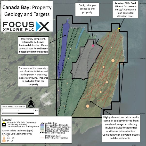
Figure 1: Canada Bay Property Geology and Targets
Geological Summary
The Canada Bay Property lies on the north-eastern side of the Great Northern Peninsula, within the Humber Zone, which preserves the ancient continental margin of North America. The zone consists of old basement rocks overlain by Cambrian to Ordovician limestone, marble, sandstone, and shale (“platform” rocks), later overridden by thrust slices of transported rock (“allochthons”) during the Taconic mountain-building event. The Doucers Valley Fault System, a long-lived north-north-east-trending structure, marks a major break in the Appalachian orogen and was reactivated repeatedly through the Palaeozoic3. In the White Bay area, roughly 100 km south of the Property, gold is associated with secondary fault zones related to this system, including the Thor and Rattling Brook4 deposits.
The Property covers about 21.75 km², its eastern part is underlain by the Maiden Point Formation, sandstone, shale and siltstone with minor mafic to intermediate volcanic rocks, inferred to be Early Cambrian or older and part of the Hare Bay Allochthon; the formation is interpreted from imagery to be heavily faulted and sheared. Platform rocks lie to the west, including Middle Ordovician marble (Table Head Formation) and siltstone and shale (Goose Tickle Formation), separated from the Maiden Point Formation by a thrust contact5 . This arrangement, with platform rocks in the west, an allochthon thrust over them in the east and north-north-east faults cutting both, is broadly comparable with White Bay area -which hosts the Thor and Rattling Brook deposits, among others6- where the allochthon lies east of the Doucers Valley Fault System and structurally overlies the platform rocks4.
Orogenic gold mineralisation in Newfoundland is commonly hosted in second- and higher-order structures and deformation zones branching from crustal-scale fault systems7 8, which are interpreted to have acted as the main fluid conduits. Canada Bay is inferred to be located within a secondary fault structure to the Doucers Valley Fault System, with much of the Maiden Point Formation being heavily faulted and inferred to be a deformation zone, and thus may be a prospective terrane for gold mineralisation.
The best-known occurrence, Mustard Cliff, is exposed in sea cliffs in the north-east of the property5. It is a rusty, pyritic sericite schist cut by a stockwork of quartz veins with brown-weathering carbonate alteration, up to about 25 m wide and traced for about 80 m along strike, beside a north-north-east-trending fault east of and parallel to the thrust contact. A sample from the zone returned 0.61 g/t Au, and the 1980s operator considered the mineralisation spatially, and probably genetically, related to the fault, with potential for wider alteration along other north-north-east faults. Faulting with quartz veining and sericite–pyrite–carbonate alteration is characteristic of orogenic gold systems9 and is reported at the Thor deposit10.
The faulted carbonate and fine-grained platform rocks in the west provide a second, conceptual target: sediment-hosted gold, in which very fine gold is carried in pyrite in carbonate-bearing rocks. This is analogous to the Saint-André-de-Ristigouche showing in the Gaspé Peninsula, Quebec, Canada11. No such deposit has been demonstrated in Newfoundland, so this remains an untested concept.
Despite its setting, the Property has been explored only at reconnaissance level (see “Review of historical exploration”), leaving its fault structures largely untested.
Review of Historical Exploration
Very limited work has been carried out on Canada Bay;
Between November 1985 and June 1986, Shear Exploration Limited4 carried out prospecting and rock sampling; the work centred on an altered zone exposed in sea cliffs at Mustard Cliff – which lies in the extreme north of the Canada Bay Property, as described above.
In 1988, BP Resources Canada12 completed a regional-scale lake sediment sampling programme, including Canada Bay. This work identified elevated arsenic (upto 20 ppm As) in the east of the Property, 2-5 km along strike of the Mustard Cliff Gold Occurrence. No significant gold enrichment was noted in lake sediment.
Exploration Targets and Proposed Exploration
The principal target on the Canada Bay is gold mineralisation associated with faulting in the east of the Property. This faulting was inferred to have formed during major mountain-building events; during such events, hot fluids moving along faults and shear zones deposit gold, usually with pyrite and arsenic-bearing minerals, in quartz veins and in the altered rock beside them9.
The Maiden Point Formation is a favourable host in principle. Its interbedded sandstone, shale and mafic to intermediate volcanic rocks differ in strength, so when deformed they may have fractured and opened along faults, creating pathways and space for veins, and the iron-bearing volcanic layers can react with gold-bearing fluids to precipitate pyrite and gold. Thrusting emplaced the formation, and imagery suggests it is heavily faulted and sheared. Gold has also been reported from graphitic shale assigned to the Maiden Point Formation at Gunners Cove on the northern Great Northern Peninsula13, where samples reported by White Metal Resources Corp. reported results of up to 5.86 g/t Au in 201714.
The best evidence on the Property is at Mustard Cliff, where a zone of rusty, pyritic sericite schist, up to about 25 m wide and traced for about 80 m along strike, is cut by a stockwork of quartz veins and carbonate alteration and lies beside a north-north-east-trending fault. A sample from the zone returned 0.61 g/t Au, and the 1980s operator inferred other north-north-east fault zones from lineaments4. Regional lake-sediment sampling by BP Resources Canada in 1988 returned elevated arsenic in the central to eastern part of the Property, along strike of the Mustard Cliff gold occurrence; arsenic is commonly enriched with gold in orogenic systems.
The current geochemical sampling and geological prospecting programme, which commended 8 November 2026, will test, through systematic outcrop sampling, the strike extension of Mustard Cliff in the vicinity of elevated arsenic in lake sediments and inferred faulting.
An additional, conceptual target of sediment-hosted micron gold exists in the west of the Property, centred on fractured and sheared calcareous lithologies that could have trapped auriferous fluids, similar to other sediment-hosted gold occurrences elsewhere in eastern Canada11. The programme will complete a small reconnaissance survey on the western part of the Property.
REFERENCES
1 | Harrington, M., Collins, R. and Elgert, L. (2023) NI 43-101 Technical Report and Updated Mineral Resource Estimate on the Thor Deposit, Viking Project, White Bay Area, Newfoundland and Labrador, Canada. Technical report prepared by Mercator Geological Services Limited and AGP Mining Consultants Inc. Report dated 20 December 2023; effective date 24 October 2023 |
2 | Harrington, M. and Cullen, M. (2019) NI 43-101 Technical Report and Updated Mineral Resource Estimate on the Rattling Brook Gold Deposit, Great Northern Project, White Bay Area, Newfoundland, Canada. Technical report prepared by Mercator Geological Services Limited. Effective date: 23 January 2019 |
3 | Minnett, M., Sandeman, H.A. and Wilton, D. (2010) ‘Regional setting of gold mineralization at the Viking property, southern White Bay, Newfoundland’, in Current Research (2010). St. John’s: Newfoundland and Labrador Department of Natural Resources, Geological Survey, Report 10-1, pp. 51–64 |
4 | Kerr, A. (2004) ‘An overview of sedimentary-rock-hosted gold mineralization in western White Bay (NTS map area 12H/15)’, in Current Research 2004. St. John’s: Newfoundland Department of Mines and Energy, Geological Survey, Report 04-1, pp. 23–42. |
5 | French, V.A. (1987) Canada Bay Project, Licence No. 2762: report on 1986 exploration, NTS 12 I/9. Clarke’s Beach, Newfoundland: Shear Exploration Limited. Newfoundland and Labrador Geological Survey, Assessment File 012I/0186. |
6 | https://resourceworld.com/gold-hunter-resources-prepares-for-great-northern-drilling-newfoundland/ |
7 | Dubé, B. and Lauzière, K. (1997). Gold metallogeny of the Cape Ray Fault Zone, southwest Newfoundland. Geological Survey of Canada report, DOI 10.4095/209256 |
8 | Kerr, A. (2006). Silurian rocks of the Sops Arm group, western Newfoundland: some new food for future digestion. In Current Research, Newfoundland and Labrador Department of Natural Resources, Geological Survey, Report 06-1, pages 91–117. |
9 | Groves, D.I., Goldfarb, R.J., Gebre-Mariam, M., Hagemann, S.G. and Robert, F. (1998) ‘Orogenic gold deposits: a proposed classification in the context of their crustal distribution and relationship to other gold deposit types’, Ore Geology Reviews, 13(1–5), pp. 7–27 |
10 | Minnett, M., Sandeman, H. and Wilton, D. (2012) ‘Geochemistry of the host rocks and timing of gold-electrum mineralization at the Viking property, Newfoundland’, in Current Research (2012). St. John’s: Newfoundland and Labrador Department of Natural Resources, Geological Survey, Report 12-1, pp. 61–84 |
11 | Garnier, V., Malo, M., Dubé, B., Chagnon, A. and Beaudoin, G. (2007) ‘Carlin-type gold mineralization at Saint-André-de-Ristigouche, Gaspé Peninsula (Québec), Canadian Appalachians’, Mineralium Deposita, 42(6), pp. 639–662. doi:10.1007/s00126-007-0133-7. |
12 | Holmes, J.M. (1988) 1988 status report, Canada Bay Project, Newfoundland (N.T.S. 12 I/09 & 12 I/16). BP Resources Canada Limited. Newfoundland and Labrador Geological Survey, Assessment File 012I/0313 |
13 | Hashmi, S. (2019) ‘Surficial geological survey for assessing mineral resource potential, Great Northern Peninsula: preliminary results’, in Current Research (2019). St. John’s: Newfoundland and Labrador Department of Natural Resources, Geological Survey, Report 19-1, pp. 211–225 |
14 |
GLOSSARY
Term | Definition |
Allochthon | A large body of rock that has been moved a long way, usually by thrusting, from where it formed. Rock that formed where it is found is described as autochthonous. |
Appalachian orogen | The ancient mountain belt, formed mainly during the Palaeozoic, that runs along the eastern side of North America and includes Newfoundland. |
Auriferous | Gold-bearing. |
Basement | The older rocks that lie beneath younger layers of sedimentary rock. |
Biogeochemical sampling | Sampling of plant material, such as twigs or needles, to detect metals in the ground below. |
Carbonate | Rock or mineral made mainly of calcium, magnesium or iron combined with carbon and oxygen. Limestone, marble and dolomite are carbonate rocks. |
Channel sample | A series of rock chips taken in a continuous line across an exposure, so that it represents the width sampled. |
Crustal-scale and secondary faults | A crustal-scale fault extends deep into the Earth's crust and can run for tens to hundreds of kilometres. Secondary (or second-order) faults are smaller structures that branch from, or lie close to, a major fault. |
Cut-off grade | The lowest grade included when a Mineral Resource is calculated. |
Doucers Valley Fault System | A long-lived system of faults, trending north-north-east, in the White Bay area of Newfoundland. It was active at various times during the Palaeozoic, and gold mineralisation, including the Thor and Rattling Brook deposits, is associated with it and with related faults. |
Fault, shear zone, deformation zone | A fault is a break in rock along which the two sides have moved. A shear zone is a band of rock deformed by that movement, and a deformation zone is any band of strongly faulted, folded or sheared rock. Fluids can travel along them. |
Grab sample | A single piece or handful of rock selected by the geologist. A selective grab sample is chosen because it looks mineralised, so it may not represent the wider rock. |
Graphitic shale | Dark shale containing graphite, a form of carbon. |
Historical estimate | A resource estimate made earlier that the current company has not verified. A Qualified Person has not done enough work to classify it as a current Mineral Resource, and it should not be relied upon. |
Humber Zone | The western of Newfoundland's four main geological zones, which preserves the ancient continental margin of North America. |
Lake sediment sampling | Sampling of the mud on a lake bottom. Its chemistry reflects the rock and soil in the area draining into the lake, so it is used as a regional exploration tool. Elevated metals, such as arsenic, point to areas for follow-up but do not by themselves show that gold is present. |
Lineament | A straight or gently curved line on a map or in imagery, often reflecting a fault. |
Mafic, intermediate | Descriptions of volcanic rock composition. Mafic rocks, such as basalt, are dark and rich in iron and magnesium. Intermediate rocks, such as andesite, lie between mafic and silica-rich rocks. |
Micron gold | Gold in grains so fine that they cannot be seen with the naked eye or an ordinary microscope, often held within pyrite (iron sulphide). |
Orogenic gold | Gold deposited in quartz veins and the altered rock beside them, along faults and shear zones, during mountain-building (orogeny). |
Phyllite, slate | Fine-grained rocks formed from mudstone by heat and pressure. Slate splits easily into flat sheets, and phyllite is slightly coarser with a silky sheen. |
Platform rocks | Layered limestone, dolomite, sandstone and shale laid down in shallow seas on the edge of the ancient continent. |
Schist, sericite | Schist is a rock, formed under heat and pressure, in which flaky minerals line up so that it splits easily. Sericite is a fine-grained white mica. |
Sediment-hosted gold | Gold held in sedimentary rocks, such as mudstone or carbonate rock. The best-known examples are the Carlin-type deposits of Nevada. |
Stockwork | A network of small veins. |
Thrust, thrust contact | A thrust is a low-angle fault along which one body of rock has been pushed over another. A thrust contact is the boundary formed by that movement. |
QUALIFIED PERSON STATEMENT
The technical information contained in this announcement has been reviewed and approved by Mr Nicholas O’Reilly (MSc, DIC, MIMMM QMR, MAusIMM, FGS), who is a qualified geologist and acts as the Qualified Person under the AIM Note for Mining and Oil & Gas Companies. Mr O’Reilly is a principal consultant working for Mining Analyst Consulting Ltd, which is providing independent technical review to Focus Xplore PLC.
**ENDS**
Enquiries:
Dave Russell | info@focusXplore.com | Focus Xplore PLC | Executive Director |
James Biddle Roland Cornish | +44 (0) 207 628 3396 | Beaumont Cornish Limited | Nominated Adviser |
Jason Robertson | +44 (0) 207 374 2212 | First Equity Limited | Corporate Broker |
Corporate Website: www.focusXplore.com | LinkedIn: Focus Xplore PLC | X: @focusXplore | |
About Reach Announcements
This is a Reach announcement. Reach is an investor communication service aimed at assisting listed and unlisted (including AIM quoted) companies to distribute media only / non-regulatory news releases into the public domain. Information required to be notified under the AIM Rules for Companies, Market Abuse Regulation or other regulation would be disseminated as an RNS regulatory announcement and not on Reach. This announcement is not authorised for distribution into North America or any other jurisdiction where to do so would constitute a violation of the relevant laws or regulations of that jurisdiction
This information is provided by Reach, the non-regulatory press release distribution service of RNS, part of the London Stock Exchange. Terms and conditions relating to the use and distribution of this information may apply. For further information, please contact rns@lseg.com or visit www.rns.com.
RNS may use your IP address to confirm compliance with the terms and conditions, to analyse how you engage with the information contained in this communication, and to share such analysis on an anonymised basis with others as part of our commercial services. For further information about how RNS and the London Stock Exchange use the personal data you provide us, please see our Privacy Policy.