
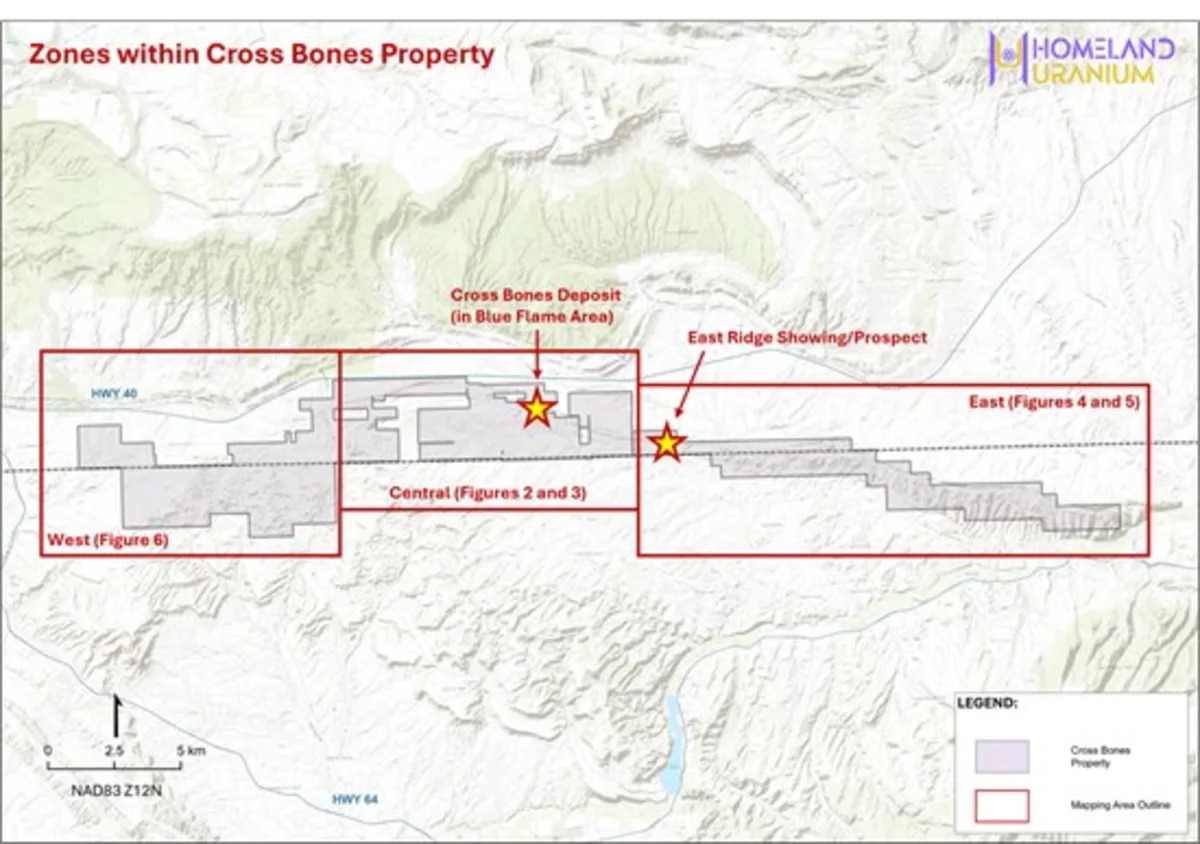
Vancouver, British Columbia--(Newsfile Corp. - July 30, 2026) - Homeland Uranium Corp. (TSXV: HLU) (OTCQB: HLUCF) (FSE: D3U) ("Homeland" or the "Company") is pleased to report geochemical uranium results of up to 1,820 ppm U (2,146 ppm U3O8 equivalent) from its May 2026 mapping and rock sampling program at the 100%-owned Cross Bones Uranium Project in northwestern Colorado (see Figure 1).
Samples also returned elevated vanadium values of up to 1,640 ppm V. Sandstone-hosted uranium deposits throughout the Colorado Plateau commonly contain significant vanadium mineralization, making the presence of vanadium an encouraging indicator of the mineralizing system.
The results confirm surface uranium mineralization across multiple target areas, including the Cross Bones Uranium Deposit (Blue Flame Area) and the newly discovered East Ridge Showing, further strengthening drill targets ahead of Homeland's inaugural drill program planned for this fall.
"These results represent another important step in advancing the Cross Bones Project toward drilling," said Roger Lemaitre, President and CEO of Homeland. "We've now confirmed uranium mineralization at surface across multiple target areas, including the Cross Bones Deposit and the newly discovered East Ridge Showing. When combined with our historical database and recently issued drill permit, we believe we have a strong technical foundation for our inaugural drill program this fall. We're particularly encouraged by the emerging potential at East Ridge, where early surface results suggest there may be additional opportunities beyond the known deposit."
Cross Bones Uranium Deposit (Blue Flame Area)
Thirty-nine rock samples were collected in the Blue Flame Area where the Cross Bones Uranium Deposit is exposed at surface (see Figures 2 and 3).
The highest-grade sample returned 1,820 ppm U (2,146 ppm U3O8 equivalent) from a sandstone outcrop located approximately 650 m east and along strike of the outcropping Cross Bones Uranium Deposit (see Table 1 and Figure 2).
Several samples also returned elevated vanadium values ranging up to 1,640 ppm V (see Table 1 and Figure 2) consistent with many sandstone-hosted uranium deposits in the Colorado Plateau that commonly contain significant concentrations of vanadium.
Uranium and vanadium mineralization was observed within sandstone, coal, and shale, with several uranium-bearing samples spatially associated with mapped fault structures.
East Ridge Showing
The Company's newly discovered East Ridge Showing, located approximately 5 km east-southeast of the Cross Bones Area, returned anomalous uranium values ranging from 106 – 231 ppm U (see Figures 4 and 5 and Table 1) from surface outcrop sampling.
The East Ridge samples were collected from radioactive sandstone and coal outcrops occurring intermittently over approximately 500 metres of strike length within the Sego Sandstone Formation.
While additional geological mapping and sampling are planned to better define the target before drilling, the results confirm the presence of both uranium and vanadium mineralization and demonstrate the potential for additional mineralized zones beyond the known Cross Bones Deposit.
Cross Bones West
Reconnaissance sampling was also completed in the far western portion of the property to evaluate favorable stratigraphy and structure features identified during field mapping (Figure 6).
Eleven outcrop samples returned uranium values ranging from 3.4 to 13.6 ppm U and vanadium values ranging from 51 to 123 ppm V (see Table 1).
Preparing for the Maiden Drill Program
The results from Homeland's mapping program have now been integrated with the Company's recently acquired historical exploration database to finalize drill targeting.
The upcoming drill program is designed to:
Twin selected historical drill holes to validate historical results;
Confirm continuity of mineralization within select portions of the Cross Bones Uranium Deposit; and
Determine the geological controls on uranium mineralization to support future expansion and delineation drilling.
Additional geological mapping and sampling programs are also being planned to further evaluate the East Ridge Showing and other prospective targets identified during the May 2026 exploration program.
Coyote Basin Winter Drilling Results
Homeland has also received analytical results from the final 25 holes of the 33 holes completed during the 2025-2026 reverse circulation drill ("RCD") campaign completed at the Coyote Basin Uranium Project (see Table 2).
The holes were drilled within both the Central and Southern Drill Areas. All analyzed samples, with one exception, returned uranium concentrations of 30 ppm U or less.
Hole CB-RC-0042 intersected 1.52 m (5 ft) of 67 ppm U from 44.2 m to 45.72 m (145 ft to 150 ft). Samples were collected from drill cuttings obtained from within the zones of elevated radioactivity identified through downhole spectral gamma ray probing.
As part of Homeland's quality assurance and quality control ("QA/QC") program, selected samples will be submitted to the Saskatchewan Research Council (SRC) for independent verification of the SGS Laboratories analytical results.
The Company will continue reviewing the results of the drill program and may consider additional exploration at Coyote Basin should further work indicate uranium mineralization is not adequately represented by the current drill spacing or that reverse circulation drilling affected sample recovery.
About Homeland Uranium Corp.
Homeland Uranium is a mineral exploration company focused on becoming a premier US-focused and resource-bearing uranium explorer and developer. The Company is 100% owner of the Cross Bones and Coyote Basin uranium projects in northwestern Colorado.
Sampling and QA/QC
Rock samples for the Cross Bones Property 2026 mapping program were collected selectively from outcrop and mineralized exposures and are considered grab samples, which are inherently selective in nature and may not be representative of underlying mineralization. Sample selection was based on counts per second (cps) readings from either (or both) a calibrated CT007-M instrument ("CT-007") or a portable gamma-ray spectrometer PGIS-2 ("PGIS"). Samples were placed in sealed bags and transported under chain of custody procedures to Paragon Geochemical Laboratories in Sparks, Nevada for preparation and analysis. Analytical work included Paragon's PREP-PKG sample preparation and 48-element multi-acid digestion with ICP-MS analysis. Paragon's methods are ISO 17025:2017 accredited and valid through multiple international proficiency testing programs.
During the Coyote Basin 2025-2026 drill program, reverse circulation chip samples were taken at 5 ft long intervals for geochemical analysis and were sent to SGS Laboratories in Lakefield, Ontario. Samples were shipped in secure containment for preparation, processing and multi-element analysis by Sodium Peroxide Fusion and Inductively Coupled Plasma Optical Emission Spectrometry (Na2O2; ICP-OES). Samples were chosen for analysis based on downhole probing radiometric equivalent grades above 0.005 % eU3O8. SGS Lab is certified ISO 17043: General requirements for proficiency testing. Blanks, standard reference materials, and repeats are inserted into the sample stream at regular intervals by HLU and the SGS in accordance with each's respective quality assurance/quality control (QA/QC) procedures.
All depths and intervals reported are drilled depths and downhole lengths, unless otherwise stated. True thicknesses have not yet been determined.
Qualified Person
Nancy Normore, P.Geo., the Company's Vice President, Exploration, is a Qualified Person as defined in NI 43-101, and has reviewed and approved the technical content of this news release.
For further information, please contact:
Roger Lemaitre
President & Chief Executive Officer
Homeland Uranium Corp.
Tel: 306-713-1401
Email: info@homeland-uranium.com
Investor Relations
Kin Communications Inc.
Tel: 604-684-6730
Email: HLU@kincommunications.com
Neither the TSX Venture Exchange nor its Regulation Services Provider (as that term is defined in the policies of the TSX Venture Exchange) accepts responsibility for the adequacy or accuracy of this news release.
Forward-Looking Statements
This news release contains "forward-looking statements" within the meaning of applicable securities legislation. Such forward-looking statements include, without limitation, statements regarding the Company's exploration strategy, interpretation of geological and analytical results, planned drilling and exploration activities at the Cross Bones Project, planned follow-up mapping and sampling programs, the submission of selected Coyote Basin samples for independent QA/QC verification, and the timing, scope and objectives of future exploration programs.
These forward-looking statements reflect the Company's current views with respect to future events and are necessarily based upon a number of assumptions that, while considered reasonable by the Company, are inherently subject to significant operational, business, economic and regulatory uncertainties and contingencies. These assumptions include, among other things: conditions in general economic and financial markets; accuracy and reliability of analytical results; geological interpretations derived from mapping, sampling, radiometric surveys and future drilling; timing and amount of capital expenditures; timely performance of available laboratory and other related services; future operating costs; the availability of skilled labour and no labour related disruptions at any of the Company's operations; no unplanned delays or interruptions in scheduled activities; all necessary permits, licenses and regulatory approvals for operations are received in a timely manner; the ability to secure and maintain title and ownership to properties and the surface rights necessary for operations; and the Company's ability to comply with environmental, health and safety laws. The foregoing list of assumptions is not exhaustive.
The Company cautions the reader that forward-looking statements involve known and unknown risks, uncertainties and other factors that may cause actual results and developments to differ materially from those expressed or implied by such forward-looking statements contained in this news release and the Company has made assumptions and estimates based on or related to many of these factors. Such factors include, without limitation: the timing and content of work programs; results of exploration activities and development of mineral properties; the interpretation and uncertainties of drilling results and other geological data; receipt, maintenance and security of permits and mineral property titles; environmental and other regulatory risks; project costs overruns or unanticipated costs and expenses; availability of funds; and general market and industry conditions.
Forward-looking statements are based on the expectations and opinions of the Company's management on the date the statements are made. The assumptions used in the preparation of such statements, although considered reasonable at the time of preparation, may prove to be imprecise and, as such, readers are cautioned not to place undue reliance on these forward-looking statements, which speak only as of the date the statements were made. The Company undertakes no obligation to update or revise any forward-looking statements included in this news release if these beliefs, estimates and opinions or other circumstances should change, except as otherwise required by applicable law.
Figure 1: Cross Bones Property and Mapping Areas with the recently discovered East Ridge Showing and the Cross Bones Uranium Deposit Location.
To view an enhanced version of this graphic, please visit:
https://images.newsfilecorp.com/files/10583/307251_59c6d7fbb4e3fa4b_002full.jpg
Figure 2: Sample results (ppm U/V) underlain by the PGIS Ground Radiometric Survey results (cps) for the Blue Flame Area (east) in the area of the outcropping Cross Bones Uranium Deposit.
To view an enhanced version of this graphic, please visit:
https://images.newsfilecorp.com/files/10583/307251_59c6d7fbb4e3fa4b_003full.jpg
Figure 3: Sample results (ppm U/V) underlain by the PGIS Ground Radiometric Survey results (cps) for the Blue Flame Area (west).
To view an enhanced version of this graphic, please visit:
https://images.newsfilecorp.com/files/10583/307251_59c6d7fbb4e3fa4b_004full.jpg
Figure 4: Sample results (ppm U/V) underlain by the PGIS Ground Radiometric Survey results (cps) for the recently discovered East Ridge Showing.
To view an enhanced version of this graphic, please visit:
https://images.newsfilecorp.com/files/10583/307251_59c6d7fbb4e3fa4b_005full.jpg
Figure 5: Sample results (ppm U/V) underlain by the PGIS Ground Radiometric Survey results (cps) for the eastern mapping area of the Cross Bones Property.
To view an enhanced version of this graphic, please visit:
https://images.newsfilecorp.com/files/10583/307251_59c6d7fbb4e3fa4b_006full.jpg
Figure 6: Sample results (ppm U/V) underlain by the PGIS Ground Radiometric Survey results (cps) for the western mapping area of the Cross Bones Property.
To view an enhanced version of this graphic, please visit:
https://images.newsfilecorp.com/files/10583/307251_59c6d7fbb4e3fa4b_007full.jpg
Table 1: Results for the Spring 2026 Cross Bones Mapping Program. Samples returning above 80 cps (CT-007) were sent for Geochemical Analysis.
Sample # | UTM E | UTM N | Elev m | Elev ft | Lith | CPS | CPS | Instrument | Areav | U ppm | V ppm |
1 | 673449 | 4454666 | 1767 | 5797 | Coal Shale | 130 | 80 | CT007 | XBW | 9.37 | 101 |
2 | 675536 | 4452649 | 1811 | 5942 | Coal Shale | 130 | 80 | CT007 | XBW | 7.75 | 123 |
3 | 675583 | 4453933 | 1796 | 5892 | Coal Shale | 140 | 80 | CT007 | XBW | 3.4 | 71 |
4 | 675905 | 4453746 | 1803 | 5915 | Coal Shale | 120 | 600 | CT007 | XBW | 5.97 | 74 |
5 | 677473 | 4453690 | 1749 | 5738 | Sandstone | 120 | 80 | CT007 | XBW | 5.15 | 86 |
6 | 678085 | 4453211 | 1755 | 5758 | Mudstone | 92 | 85 | CT007 | XBW | 3.57 | 69 |
7 | 678285 | 4453319 | 1737 | 5699 | Coal Shale | 110 | 87 | CT007 | XBW | 5.4 | 97 |
8 | 678518 | 4453793 | 1746 | 5728 | Mudstone | 115 | 85 | CT007 | XBW | 4.32 | 51 |
9 | 678520 | 4453783 | 1746 | 5728 | Coal Shale | 140 | 100 | CT007 | XBW | 3.94 | 97 |
10 | 678915 | 4454020 | 1738 | 5702 | Coal Shale | 130 | 86 | CT007 | XBW | 13.6 | 69 |
11 | 679069 | 4453520 | 1756 | 5761 | Coal Shale | 110 | 85 | CT007 | XBW | 4.78 | 77 |
12 | 689381 | 4456839 | 1745 | 5725 | Sand/ | 500 | CT007 | BFW | 26.3 | 60 | |
13 | 689565 | 4456789 | 1729 | 5673 | Coal | 155 | CT007 | BFW | 11.4 | 193 | |
14 | 689918 | 4456548 | 1731 | 5679 | Shale | 1050 | CT007 | BFW | 21.6 | 96 | |
15 | 690007 | 4456489 | 1719 | 5640 | Coal Shale | 100 | 80 | CT007 | BFW | 3.41 | 61 |
16 | 690354 | 4456393 | 1708 | 5604 | Coal Shale | 1020 | 250 | CT007 | BFW | 110 | 157 |
17 | 690445 | 4456441 | 1711 | 5614 | Coal Shale | 110 | 90 | CT007 | BFW | 7.91 | 56 |
18 | 690446 | 4456442 | 1713 | 5620 | Fault | 110 | 85 | CT007 | BFW | 2.99 | 71 |
19 | 690671 | 4456402 | 1715 | 5627 | Coal | 126 | 115 | CT007 | BFE | 14.5 | 17 |
20 | 690795 | 4456392 | 1735 | 5692 | Sandstone | 119 | 120 | CT007 | BFE | 42.9 | 26 |
21 | 690795 | 4456285 | 1728 | 5669 | Sandstone | 907 | PGIS_02 | BFE | 22.4 | 45 | |
22 | 690800 | 4456398 | 1732 | 5682 | Coal | 1200 | 250 | CT007 | BFE | 356 | 50 |
23 | 690800 | 4456399 | 1736 | 5696 | Sandstone | 274 | 135 | CT007 | BFE | 21.5 | 25 |
24 | 690801 | 4456279 | 1724 | 5656 | Sandstone | 400 | 150 | CT007 | BFE | 4.43 | 114 |
25 | 690802 | 4456279 | 1723 | 5653 | Coal | 4000 | 250 | CT007 | BFE | 294 | 622 |
26 | 690804 | 4456280 | 1726 | 5663 | Sandstone | 3000 | 400 | CT007 | BFE | 179 | 1640 |
27 | 690813 | 4456278 | 1724 | 5656 | Sandstone | 575 | PGIS_02 | BFE | 19.9 | 123 | |
28 | 690815 | 4456384 | 1735 | 5692 | Sandstone | 150 | 111 | CT007 | BFE | 13.7 | 35 |
29 | 690838 | 4456321 | 1717 | 5633 | Sandstone | 115 | 84 | CT007 | BFE | 9.46 | 46 |
30 | 690874 | 4456289 | 1720 | 5643 | Sandstone | 350 | 140 | CT007 | BFE | 45.3 | 24 |
31 | 690977 | 4456330 | 1728 | 5669 | Sandstone | 2200 | PGIS_02 | BFE | 307 | 78 | |
32 | 690981 | 4456332 | 1714 | 5623 | Shale | 385 | 195 | CT007 | BFE | 12.8 | 111 |
33 | 691046 | 4456276 | 1716 | 5630 | Sandstone | 150 | 100 | BFE | 18.2 | 17 | |
34 | 691060 | 4456189 | 1712 | 5617 | Sandstone | 2000 | 350 | CT007 | BFE | 120 | 25 |
35 | 691062 | 4456190 | 1701 | 5581 | Fault in | 1700 | 200 | CT007 | BFE | 16 | 58 |
36 | 691078 | 4456288 | 1713 | 5620 | Sandstone | 350 | 150 | CT007 | BFE | 11.4 | 39 |
37 | 691090 | 4456291 | 1726 | 5663 | Shale | 567 | CT007 | BFE | 62.8 | 270 | |
38 | 691092 | 4456290 | 1729 | 5673 | Sandstone | 500 | 177 | CT007 | BFE | 31.8 | 293 |
39 | 691096 | 4456293 | 1730 | 5676 | Sandstone | 140 | 150 | CT007 | BFE | 4.06 | 55 |
40 | 691108 | 4456143 | 1712 | 5617 | Sandstone | 393 | PGIS_02 | BFE | 2.12 | 33 | |
41 | 691145 | 4456158 | 1717 | 5633 | Sandstone | 1400 | PGIS_02 | BFE | 8.22 | 41 | |
42 | 691197 | 4456418 | 1729 | 5673 | Sandstone | 120 | 105 | CT007 | BFE | 11.6 | 35 |
43 | 691289 | 4456102 | 1727 | 5666 | Coal | 179 | 103 | CT007 | BFE | 297 | 46 |
44 | 691372 | 4456173 | 1737 | 5699 | Sandstone | 298 | 208 | CT007 | BFE | 15 | 16 |
45 | 691372 | 4456172 | 1750 | 5741 | Sandstone | 155 | 100 | CT007 | BFE | 6.56 | 17 |
46 | 691373 | 4456176 | 1759 | 5771 | Sandstone | 350 | 260 | CT007 | BFE | 18.5 | 29 |
47 | 691373 | 4456177 | 1749 | 5738 | Coal | 470 | 250 | CT007 | BFE | 65.6 | 44 |
48 | 691374 | 4456177 | 1757 | 5764 | Sandstone | 2200 | CT007 | BFE | 1820 | 24 | |
49 | 691477 | 4456314 | 1746 | 5728 | Siltstone | 650 | 150 | CT007 | BFE | 44.6 | 58 |
50 | 691477 | 4456314 | 1746 | 5728 | Sandstone | 900 | 100 | CT007 | BFE | 16.9 | 164 |
51 | 695297 | 4455408 | 1673 | 5489 | Sandstone | 1280 | CT007 | ERS | 106 | 41 | |
52 | 695321 | 4455404 | 1683 | 5522 | Sandstone | 1500 | 200 | CT007 | ERS | 6.1 | 23 |
53 | 695322 | 4455406 | 1682 | 5518 | Coal | 1800 | CT007 | ERS | 231 | 75 | |
54 | 695387 | 4455399 | 1678 | 5505 | Sandstone | 450 | 104 | CT007 | ERS | 6.08 | 12 |
55 | 695733 | 4455366 | 1687 | 5535 | Sandstone | 2300 | 250 | CT007 | ERS | 115 | 257 |
56 | 695737 | 4455365 | 1682 | 5518 | Sandstone | 2300 | 300 | CT007 | ERS | 111 | 82 |
57 | 695785 | 4455352 | 1675 | 5495 | Sandstone | 3400 | 900 | CT007 | ERS | 166 | 237 |
58 | 700450 | 4454565 | 1744 | 5722 | Coal Shale | 120 | XBE | 6.74 | 92 | ||
*All UTMs are in NAD83 Zone 12N. List does not include duplicates. |
Table 2: Drill Locations for the 2025-2026 Coyote Basin Drill Program.
Hole ID | Dip | Azimuth | Depth m | Depth ft | UTM E | UTM N | Elev m | Elev ft |
CB-RC-0023 | -90 | 0 | 341.38 | 1120 | 4454332 | 733453 | 1844 | 6050 |
CB-RC-0024 | -90 | 0 | 249.94 | 820 | 4454299 | 733288.7 | 1835 | 6020 |
CB-RC-0025 | -90 | 0 | 146.3 | 480 | 4454299 | 733088 | 1819 | 5968 |
CB-RC-0025A | -90 | 0 | 365.76 | 1200 | 4454305 | 733076 | 1811 | 5942 |
CB-RC-0026 | -90 | 0 | 213.36 | 700 | 4454300 | 732892 | 1824 | 5984 |
CB-RC-0027 | -90 | 0 | 170.69 | 560 | 4454301 | 732761 | 1824 | 5984 |
CB-RC-0028 | -90 | 0 | 164.59 | 540 | 4454298 | 732493 | 1811 | 5942 |
CB-RC-0029 | -90 | 0 | 91.44 | 300 | 4454102 | 732492 | 1812 | 5945 |
CB-RC-0030 | -90 | 0 | 109.73 | 360 | 4454098 | 732690 | 1820 | 5971 |
CB-RC-0031 | -90 | 0 | 109.73 | 360 | 4454099 | 732890 | 1845 | 6053 |
CB-RC-0032 | -90 | 0 | 132.59 | 435 | 4454101 | 733094 | 1822 | 5978 |
CB-RC-0033 | -90 | 0 | 161.54 | 530 | 4454097 | 733293 | 1835 | 6020 |
CB-RC-0034 | -90 | 0 | 193.55 | 635 | 4454126 | 733462 | 1856 | 6089 |
CB-RC-0035 | -90 | 0 | 193.55 | 635 | 4453887 | 733413 | 1859 | 6099 |
CB-RC-0036 | -90 | 0 | 128.02 | 420 | 4453903 | 733291 | 1847 | 6060 |
CB-RC-0037 | -90 | 0 | 114.3 | 375 | 4453901 | 733088 | 1840 | 6037 |
CB-RC-0038 | -90 | 0 | 102.11 | 335 | 4453901 | 732889 | 1839 | 6033 |
CB-RC-0039 | -90 | 0 | 106.68 | 350 | 4453902 | 732689 | 1811 | 5942 |
CB-RC-0040 | -90 | 0 | 100.58 | 330 | 4453905 | 732484 | 1809 | 5935 |
CB-RC-0041 | -90 | 0 | 100.58 | 330 | 4453699 | 732491 | 1811 | 5942 |
CB-RC-0042 | -90 | 0 | 109.73 | 360 | 4453706 | 732700 | 1817 | 5961 |
CB-RC-0043 | -90 | 0 | 121.92 | 400 | 4453702 | 732890 | 1835 | 6020 |
CB-RC-0044 | -90 | 0 | 131.06 | 430 | 4453699 | 733090 | 1839 | 6033 |
CB-RC-0045 | -90 | 0 | 121.92 | 400 | 4453702 | 733294 | 1853 | 6079 |
CB-RC-0046 | -90 | 0 | 137.16 | 450 | 4455902 | 731918 | 1786 | 5860 |
CB-RC-0047 | -90 | 0 | 129.54 | 425 | 4456023 | 732085 | 1820 | 5971 |
CB-RC-0048 | -90 | 0 | 249.94 | 820 | 4456361 | 732585 | 1736 | 5696 |
CB-RC-0049 | -90 | 0 | 228.6 | 750 | 4456245 | 732408 | 1829 | 6001 |
CB-RC-0050 | -90 | 0 | 167.64 | 550 | 4456187 | 732241 | 1831 | 6007 |
CB-RC-0051 | -90 | 0 | 181.36 | 595 | 4456411 | 732306 | 1800 | 5906 |
CB-RC-0052 | -90 | 0 | 152.4 | 500 | 4456318 | 732156 | 1837 | 6027 |
CB-RC-0053 | -90 | 0 | 109.73 | 360 | 4456175 | 731999 | 1783 | 5850 |
CB-RC-0054 | -90 | 0 | 86.87 | 285 | 4455852 | 732195 | 1794 | 5886 |
CB-RC-0055 | -90 | 0 | 202.69 | 665 | 4456183 | 732709 | 1841 | 6040 |
*All UTMs are in NAD83 Zone 12N.
To view the source version of this press release, please visit https://www.newsfilecorp.com/release/307251