
- Following 2 years of detailed target development, the El Segundo area is primed for Phase 1 drilling in 2026
- El Segundo is underpinned by robust Carlin-suite surface geochemistry, strong sub-surface alteration zones identified via geophysical surveys, and favourable surface alteration and structural settings recognized through mapping
- The El Segundo area has seen no historical drilling and will be tested with both RC and core across 8 planned sites totaling approximately 6,000 metres
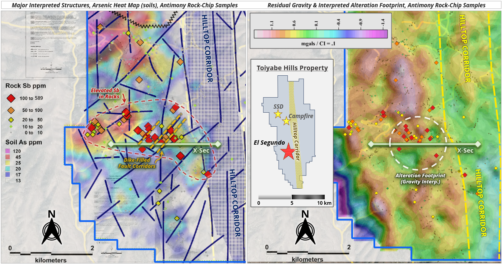
Vancouver, British Columbia, July 20, 2026 – TheNewswire - Westward Gold Inc. (CSE: WG, OTCQB: WGLIF, FSE: IM50) (“Westward” or the “Company”) is pleased to provide additional details surrounding its planned Phase I drilling campaign at the El Segundo Target (“El Segundo”), one of three target areas slated for testing with reverse circulation (“RC”) and core drilling in 2026 at the Company’s Toiyabe Hills Property in Lander County, NV (“Toiyabe Hills”, or the “Property”). This target has been developed over several field seasons through the application of Westward’s systematic, multi-disciplinary approach to greenfield gold exploration, and is now primed for its initial drill test. El Segundo is located approximately 4 km south-southeast of the SSD Target (“SSD”) and 3 km south of the Campfire Target; it sits in the footwall of the district-scale north-striking Hilltop Structural Corridor, and favourable lower-plate carbonate host rocks of the Wenban Formation are exposed at surface across most of the target area. Multiple robust datasets support this year’s decision to allocate a portion of the Company’s drilling budget to further advance and define El Segundo, including the following (see Figures 1 through 3 for visual representations of the various datasets):
-
Surface Geochemistry: A large plume of elevated Carlin-suite elements (notably arsenic) lies over and outboard of the target area – as indicated by a gridded soil survey – coincident with anomalous gold in rock-chip samples (up to 1.6 g Au/t) and the strongest antimony on the Property in rock-chip samples (up to 589 ppm Sb).
-
Geophysical Surveys: Robust geophysical datasets have been acquired through a gravity survey (2024), an airborne magnetic survey (2025), and a controlled-source audio-frequency magnetotelluric (“CSAMT”) survey (2026) – and point to gravity-interpreted alteration (decalcification) in lower-plate carbonate rocks, and strong silicification (and argillic alteration) interpreted from CSAMT data.
-
Anaconda-Style Mapping: 1:5000-scale mapping has identified surface alteration (both decalcification and silicification), northeast-striking dike-filled fault corridors, and syncline-anticline pairs indicative of compression – a favourable structural setting for Carlin-style gold exploration.
Robert Edie, Vice President of Exploration, noted: “As we’ve continued to expand our land position and associated Property-wide baseline exploration datasets, we fully anticipated that new targets would emerge along the footwall of the district-scale Hilltop Corridor, with Westward now controlling 13 km of its strike length. This setting is reminiscent of other major Nevada gold camps – notably the north area of the Carlin Trend where the Post-Gen Fault is a major control on mineralization at multiple gold mines. Phase I drilling at El Segundo will be the next step in the advancement of this target area following 2 years of data acquisition and interpretation by our team. One of the advantages of drilling in this area is that most of the drill holes will collar in lower-plate carbonate rocks, allowing for a more efficient test of regional host strata. We will also have the opportunity to drill the first-ever hole through and across the Hilltop Corridor – and we’re all very excited to get a better look at this major structural feature.”
Drilling Plan
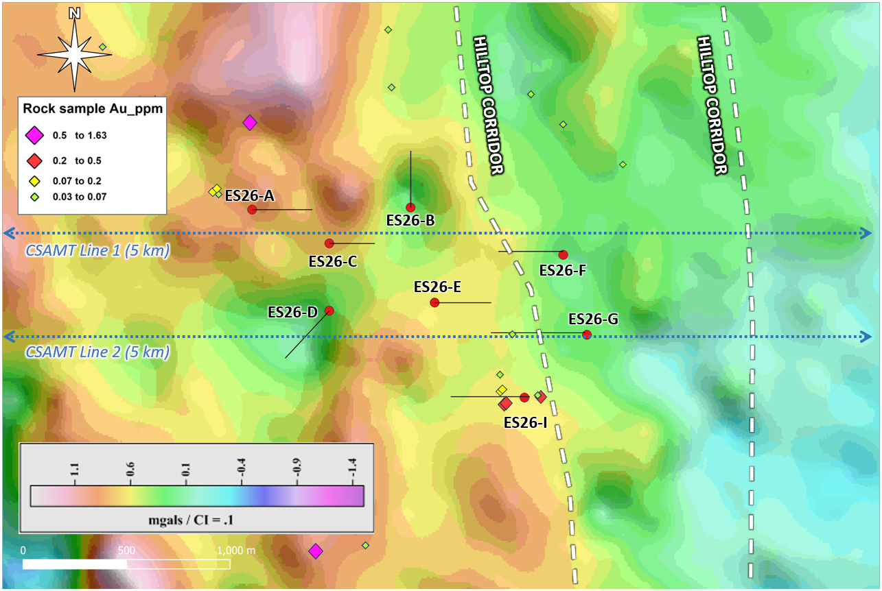
Eight drill pads have been permitted, and construction on the last remaining eastern pads at El Segundo is nearing completion (see Figure 2 below). This target will be tested with a combination of RC and core holes for a total of approximately 6,000 metres, the latter being used primarily to cross-cut major structural zones and obtain the best possible geology.
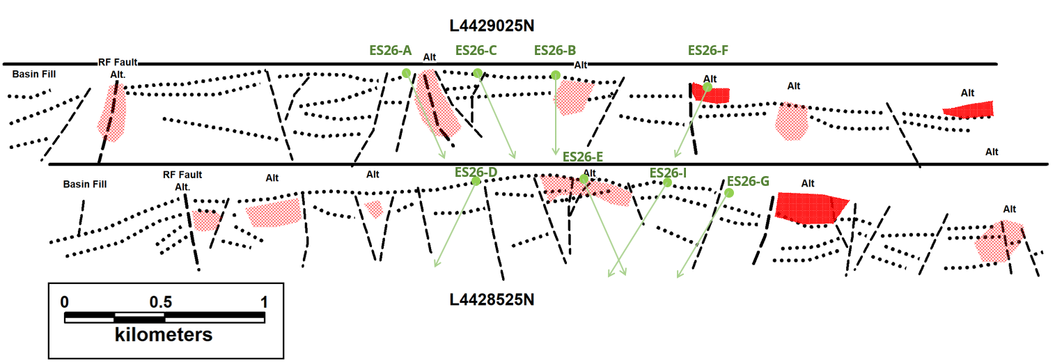
Drill hole depths have been designed with the goal of testing significant vertical extents of both the Wenban Formation and underlying Roberts Mountains Formation, the two most important host strata in the Cortez District. Real-time analysis of RC chips and drill core at site will determine the ultimate total depth of each hole. Both classic Carlin-style laterally-disseminated gold (along favourable sub-units of the Wenban Formation, for example), and higher-grade gold within dike margins and fault corridors are being targeted in this campaign. Drill hole azimuths and dips have also been modified as necessary to better intersect sub-surface zones of silica alteration (argillic alteration and jasperoids as interpreted by the recently-completed CSAMT survey), and potential zones of decalcification as interpreted by residual gravity anomalies.
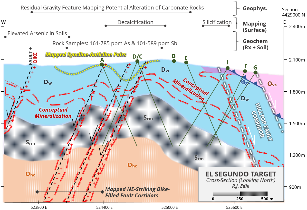
Note: Drill holes plotted on the east-west cross-section above have up to ~1 km in north-south displacement (refer to Figure 2) and are shown on the same profile for illustrative purposes.
2026 CSAMT Survey
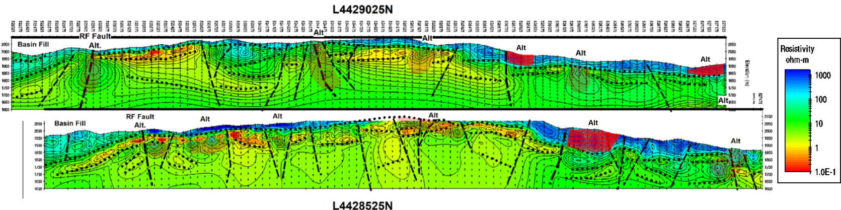
In May of 2026, the Company contracted Zonge Geosciences, Inc. of Reno, NV to conduct a 10 line-kilometre CSAMT survey across 2 east-west lines spaced 500 metres apart. Following data acquisition, results were interpreted by Mr. Jim Wright of J.L. Wright Geophysics in Spring Creek, NV – a renowned geophysicist with over 40 years of expertise within the Carlin and Cortez Districts of northern Nevada – in coordination with Westward’s team of technical experts. The primary objective of the program was to more accurately delineate structures, lithologies, and alteration related to potential mineralization at El Segundo, in order to refine discrete drill targets within the broad alteration cell of distinctive Carlin-type geochemistry.
The survey was successful in focusing Phase I drilling by resolving zones of alteration and new structural targets. High-angle structures and lithological contacts were identified with greater accuracy, along with multiple zones of alteration (see Figures 4 and 5 below). These zones are interpreted as areas of silica alteration – potentially argillic alteration and / or jasperoid – and characterized by either high resistivity (shown in hatched red in the figures below) or extremely high resistivity (greater than 1,000 ohm-m, shown in solid red). Jasperoids and silicification have been identified in surface mapping across some of the target area, however drilling and additional ground-truthing will provide greater detail regarding the specific nature of these alteration zones. Where possible, drill holes will be positioned to more effectively test these alteration zones, along with previously-identified alteration in lower-plate carbonate rocks per the 2024 gravity survey. Of particular interest is a zone of vertically-extensive alteration – identified in the northern CSAMT line – bounded by major offsetting structures (potentially an altered carbonate horst); this target will be tested from site ES26-A (see Figure 5 below). Site locations shown in Figure 5 are plotted on the CSAMT line to which they are most proximal.
In addition to the CSAMT-mapped alteration zones, several other previously-understood features are being targeted. These include: i) structural zones / dike-filled faults; ii) gravity-interpreted alteration zones; and iii) geochemical anomalies – specifically near large surface plumes of elevated antimony and arsenic (key Carlin pathfinder elements). Drill holes are planned with easterly or westerly dips, with the exception of ES26-B (dipping due north) and ES26-D (dipping to the southwest). Those two holes were specifically designed to test gravity anomalies and interpreted alteration (decalcification) in lower-plate carbonate rocks. Final hole depths will be determined based on real-time feedback in the field, and depths shown in the figures herein are illustrative.
2026 Field Season Update
-
Drilling: Core drilling continues while the Company awaits delivery of a second rig (RC), expected in a matter of weeks per the latest contractor estimate. The core rig was recently relocated to El Segundo from SSD following the completion of holes T2601 and T2602, two shallower tests designed to fill in gaps in the 3D model, improve vectoring tools (association between structure type and potential mineralization in the target area), and acclimate the crew and rig before advancing to more challenging – and deeper – holes. ES2601 (collared on pad ES26-B) is currently drilling at a depth of 145 metres, targeting a gravity-interpreted zone of alteration in lower-plate carbonate rocks. It is designed to reach a final depth of 600+ metres, pending ongoing core analysis.
-
Trenching: All 3 trenches at SSD have now been mapped, with assays for trenches 1 and 3 pending from the lab and sample collection from trench 2 nearing completion. Significant learnings from the mapping and assays (structure attributes) will influence final hole design from certain pads at SSD.
-
Mapping: 1:5000-scale Anaconda-style mapping across the Property is ongoing, with ~15 square kilometres completed to date – already qualifying as the most extensive annual campaign in the Company’s history.
-
Surface Geochemistry: Collection and analysis of surface samples will continue throughout the field season, currently 476 of 744 soil samples have been collected within the three designed grids, and collection of up to 1,000 rock-chips samples (including from road / pad cuts) remains ongoing with over 100 submitted for assays to date.
-
Geophysical Surveys: The last remaining geophysical survey (step-out gravity over the recent northern land acquisition) is due to be completed this month.
Digital Marketing Services Agreements
The Company has engaged Emerging Markets Consulting, LLC ("EMC") to provide investor relations services (the "Services") for a period of 90 days, and Westward has paid EMC a fee of US$150,000 for this engagement period. The Services include increasing awareness of the Company's activities through EMC’s social media channels and facilitating outreach and engagement with the financial community, current shareholders, prospective investors and other key stakeholders. The material disseminated will be generated using publicly-available information. EMC and its affiliates currently hold no shares in Westward Gold Inc. EMC may, however, purchase or sell Company securities in the open market or through other means based on market conditions and other factors. EMC is at arm's length to Westward, has no other relationship with the Company and neither EMC nor its principal, James Painter, has any interest, directly or indirectly, in the Company or its securities, or any right or intent to acquire such an interest, other than as disclosed herein. EMC is located at 390 North Orange Ave. Suite 2300, Orlando, FL 32801 and can be contacted at (407) 340-0226 or at jamespainter0711@gmail.com.
Additionally, the Company has engaged Hillside Consulting and Media Inc. (“Hillside”), a British-Columbia-based firm, to assist in ongoing marketing and investor relations efforts, for a period of one week. Westward has paid Hillside a fee of C$45,000 plus applicable taxes for this engagement period. Hillside will provide digital marketing services, including SEO (search engine optimization), e-mail and social media outreach, and content creation including video, in order to increase corporate awareness. The media disseminated will be generated using publicly-available information. Hillside and its affiliates currently hold no shares in Westward Gold Inc. Hillside may, however, purchase or sell Company securities in the open market or through other means based on market conditions and other factors. Hillside is at arm's length to Westward, has no other relationship with the Company and neither Hillside nor its CEO, Stephen Giberson, has any interest, directly or indirectly, in the Company or its securities, or any right or intent to acquire such an interest, other than as disclosed herein. Hillside is located at 474 Main St., Penticton, BC V2A 5C5 and can be contacted at (250) 485-3615 or at hillsideconsultingmedia@gmail.com.
Qualified Person
The technical information contained in this news release was reviewed and approved by Robert Edie, Vice President Exploration of the Company, who is a Qualified Person under National Instrument 43-101 – Standards of Disclosure for Mineral Projects. Mr. Edie is a Certified Professional Geologist (CPG) through the American Institute of Professional Geologists (AIPG).
About Westward Gold
Westward Gold is a mineral exploration company focused on developing the Toiyabe Hills Project located in the Cortez Trend area of Lander County, Nevada, and the Coyote and Rossi Projects located along the Carlin Trend in Elko County, Nevada. From time to time, the Company may also evaluate the acquisition of other mineral exploration assets and opportunities.
For further information contact:
Andrew Nelson
Chief Financial Officer
Westward Gold Inc.
+1 (604) 828-7027
The Canadian Securities Exchange has neither approved nor disapproved the contents of this news release. The Canadian Securities Exchange does not accept responsibility for the adequacy or accuracy of this news release.
This news release contains or incorporates by reference “forward-looking statements” and “forward-looking information” as defined under applicable Canadian securities legislation. All statements, other than statements of historical fact, which address events, results, outcomes, or developments that the Company expects to occur are, or may be deemed, to be, forward-looking statements. Forward-looking statements are generally, but not always, identified by the use of forward-looking terminology such as "expect", "believe", "anticipate", "intend", "estimate”, “potential”, “on track”, “forecast", "budget", “target”, “outlook”, “continue”, “plan” or variations of such words and phrases and similar expressions or statements that certain actions, events or results “may”, “could”, “would”, “might” or “will” be taken, occur or be achieved or the negative connotation of such terms.
Such statements include, but may not be limited to, information as to strategy, plans or future financial or operating performance, such as the Company’s expansion plans, project timelines, expected drilling targets, and other statements that express management’s expectations or estimates of future plans and performance.
Forward-looking statements or information are subject to a variety of known and unknown risks, uncertainties and other factors that could cause actual events or results to differ from those reflected in the forward-looking statements or information, including, without limitation, the need for additional capital by the Company through financings, and the risk that such funds may not be raised; the speculative nature of exploration and the stages of the Company’s properties; the effect of changes in commodity prices; regulatory risks that development of the Company’s material properties will not be acceptable for social, environmental or other reasons, availability of equipment (including drills) and personnel to carry out work programs, that each stage of work will be completed within expected time frames, that current geological models and interpretations prove correct, the results of ongoing work programs may lead to a change of exploration priorities, and the efforts and abilities of the senior management team. This list is not exhaustive of the factors that may affect any of the Company’s forward-looking statements or information. These and other factors may cause the Company to change its exploration and work programs, not proceed with work programs, or change the timing or order of planned work programs. Additional risk factors and details with respect to risk factors that may affect the Company’s ability to achieve the expectations set forth in the forward-looking statements contained in this news release are set out in the Company’s latest management discussion and analysis under “Risks and Uncertainties”, which is available under the Company’s SEDAR+ profile at www.sedarplus.ca. Although the Company has attempted to identify important factors that could cause actual results to differ materially, there may be other factors that cause results not to be as anticipated, estimated, described or intended. Accordingly, readers should not place undue reliance on forward-looking statements or information. The Company’s forward-looking statements and information are based on the assumptions, beliefs, expectations, and opinions of management as of the date of this press release, and other than as required by applicable securities laws, the Company does not assume any obligation to update forward-looking statements and information if circumstances or management’s assumptions, beliefs, expectations or opinions should change, or changes in any other events affecting such statements or information.